- 0 Shopping Cart

Kerala flood case study
Kerala flood case study.
Kerala is a state on the southwestern Malabar Coast of India. The state has the 13th largest population in India. Kerala, which lies in the tropical region, is mainly subject to the humid tropical wet climate experienced by most of Earth’s rainforests.

A map to show the location of Kerala
Eastern Kerala consists of land infringed upon by the Western Ghats (western mountain range); the region includes high mountains, gorges, and deep-cut valleys. The wildest lands are covered with dense forests, while other areas lie under tea and coffee plantations or other forms of cultivation.
The Indian state of Kerala receives some of India’s highest rainfall during the monsoon season. However, in 2018 the state experienced its highest level of monsoon rainfall in decades. According to the India Meteorological Department (IMD), there was 2346.3 mm of precipitation, instead of the average 1649.55 mm.
Kerala received over two and a half times more rainfall than August’s average. Between August 1 and 19, the state received 758.6 mm of precipitation, compared to the average of 287.6 mm, or 164% more. This was 42% more than during the entire monsoon season.
The unprecedented rainfall was caused by a spell of low pressure over the region. As a result, there was a perfect confluence of the south-west monsoon wind system and the two low-pressure systems formed over the Bay of Bengal and Odisha. The low-pressure regions pull in the moist south-west monsoon winds, increasing their speed, as they then hit the Western Ghats, travel skywards, and form rain-bearing clouds.
Further downpours on already saturated land led to more surface run-off causing landslides and widespread flooding.
Kerala has 41 rivers flowing into the Arabian Sea, and 80 of its dams were opened after being overwhelmed. As a result, water treatment plants were submerged, and motors were damaged.
In some areas, floodwater was between 3-4.5m deep. Floods in the southern Indian state of Kerala have killed more than 410 people since June 2018 in what local officials said was the worst flooding in 100 years. Many of those who died had been crushed under debris caused by landslides. More than 1 million people were left homeless in the 3,200 emergency relief camps set up in the area.
Parts of Kerala’s commercial capital, Cochin, were underwater, snarling up roads and leaving railways across the state impassable. In addition, the state’s airport, which domestic and overseas tourists use, was closed, causing significant disruption.
Local plantations were inundated by water, endangering the local rubber, tea, coffee and spice industries.
Schools in all 14 districts of Kerala were closed, and some districts have banned tourists because of safety concerns.
Maintaining sanitation and preventing disease in relief camps housing more than 800,000 people was a significant challenge. Authorities also had to restore regular clean drinking water and electricity supplies to the state’s 33 million residents.
Officials have estimated more than 83,000km of roads will need to be repaired and that the total recovery cost will be between £2.2bn and $2.7bn.
Indians from different parts of the country used social media to help people stranded in the flood-hit southern state of Kerala. Hundreds took to social media platforms to coordinate search, rescue and food distribution efforts and reach out to people who needed help. Social media was also used to support fundraising for those affected by the flooding. Several Bollywood stars supported this.
Some Indians have opened up their homes for people from Kerala who were stranded in other cities because of the floods.
Thousands of troops were deployed to rescue those caught up in the flooding. Army, navy and air force personnel were deployed to help those stranded in remote and hilly areas. Dozens of helicopters dropped tonnes of food, medicine and water over areas cut off by damaged roads and bridges. Helicopters were also involved in airlifting people marooned by the flooding to safety.
More than 300 boats were involved in rescue attempts. The state government said each boat would get 3,000 rupees (£34) for each day of their work and that authorities would pay for any damage to the vessels.
As the monsoon rains began to ease, efforts increased to get relief supplies to isolated areas along with clean up operations where water levels were falling.
Millions of dollars in donations have poured into Kerala from the rest of India and abroad in recent days. Other state governments have promised more than $50m, while ministers and company chiefs have publicly vowed to give a month’s salary.
Even supreme court judges have donated $360 each, while the British-based Sikh group Khalsa Aid International has set up its own relief camp in Kochi, Kerala’s main city, to provide meals for 3,000 people a day.
International Response
In the wake of the disaster, the UAE, Qatar and the Maldives came forward with offers of financial aid amounting to nearly £82m. The United Arab Emirates promised $100m (£77m) of this aid. This is because of the close relationship between Kerala and the UAE. There are a large number of migrants from Kerala working in the UAE. The amount was more than the $97m promised by India’s central government. However, as it has done since 2004, India declined to accept aid donations. The main reason for this is to protect its image as a newly industrialised country; it does not need to rely on other countries for financial help.
Google provided a donation platform to allow donors to make donations securely. Google partners with the Center for Disaster Philanthropy (CDP), an intermediary organisation that specialises in distributing your donations to local nonprofits that work in the affected region to ensure funds reach those who need them the most.

Google Kerala Donate
Tales of humanity and hope
Check your understanding.

Premium Resources
Please support internet geography.
If you've found the resources on this page useful please consider making a secure donation via PayPal to support the development of the site. The site is self-funded and your support is really appreciated.
Related Topics
Use the images below to explore related GeoTopics.
River flooding and management
Topic home, wainfleet floods case study, share this:.
- Click to share on Twitter (Opens in new window)
- Click to share on Facebook (Opens in new window)
- Click to share on Pinterest (Opens in new window)
- Click to email a link to a friend (Opens in new window)
- Click to share on WhatsApp (Opens in new window)
- Click to print (Opens in new window)
If you've found the resources on this site useful please consider making a secure donation via PayPal to support the development of the site. The site is self-funded and your support is really appreciated.
Search Internet Geography
Top posts and pages.
Latest Blog Entries
Pin It on Pinterest
- Click to share
- Print Friendly
- Arts & Culture
Get Involved
Autumn 2023

Annual Gala Dinner

Internships
The 2015 Chennai Flood: A Case for Developing City Resilience Strategies
Soumita Chakraborty , Umamaheshwaran Rajasekar
Over the last 25 years, the world has seen a rise in the frequency of natural disasters in rich and poor countries alike. Today, there are more people at risk from natural hazards than ever before, with those in developing countries particularly at risk. This essay series is intended to explore measures that have been taken, and could be taken, in order to improve responses to the threat or occurrence of natural disasters in the MENA and Indo-Pacific regions. Read More . ..
The Chennai metropolitan region (CMA), with an area of 1,189 sq kms and a population of 8,653,521, is the fourth-largest populated city in India. [1] This city, located in north eastern part of Tamil Nadu is a flat plain bounded on the east by Bay of Bengal and on the remaining three sides by Chengalpattu and Thiruvallur districts. Expansion in terms of area as well as population has led to a shift in land use and land cover patterns across the region.
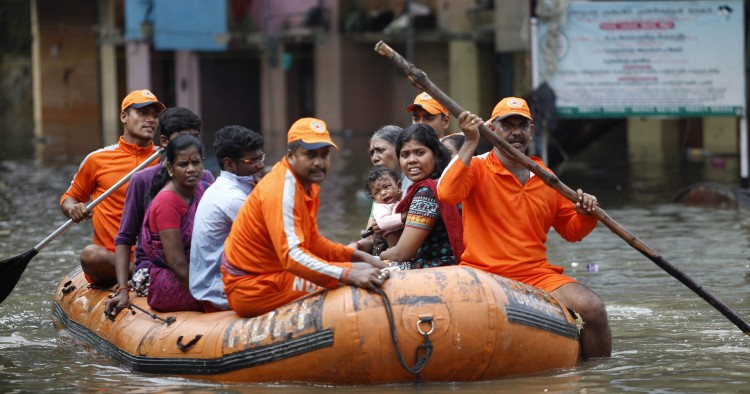
Situated along the eastern coast of India, Chennai is exposed to violent storm surges and flooding during northeast monsoons (September to November). Although local flooding is an annual phenomenon in selected parts of the city, extreme events, such as the 1918 cyclone and 1985 floods, had faded from people’s memory. [2] However, history repeated itself in the city and neighboring coastal districts in November-December 2015, when a devastating flood affected more than 4 million people, claimed more than 470 lives and resulted in enormous economic loss. [3]
The sudden and unprecedented nature of the flood led to ad hoc and uncoordinated relief and response activities by different governmental and non-governmental agencies. Industrial and commercial centers were forced to temporarily shut down their production due to loss of power, shelter and limited logistics. Amid the chaos and widespread impact, the event brought people and institutions in and outside Chennai together, to provide support to the victims affected by the flood. Help reached the affected areas and their residents from different sections of society and in variety of forms. The lessons from this case study and others like it can help urban centers elsewhere in Asia to plan for similar eventualities.
Challenges Faced During and Following the Event
Flooding often handicaps the affected community by adversely affecting its educational system, food availability, mobility and access to energy on a daily basis. Chennai was no exception: daily functions became a challenge for the entire city.
School authorities faced numerous challenges, ranging from the sudden need to shift and secure school records / admit cards and postpone exams, to maintaining physical infrastructure and equipping schools to serve as shelters. Following the event, school authorities faced yet another set of daunting tasks related to the resumption of the academic session (e.g. repairing and replacing furniture, etc.) in schools that had been shuttered (for 10 to 33 days) in various parts of the city.
Flooding often handicaps the affected community by adversely affecting its educational system, food availability, mobility and access to energy on a daily basis.
Food logistics arrangements across the affected communities included the unavailability of manufacturing capacity and delivery mechanisms. The lack of accessibility to several parts of Chennai due to severe flooding made identification of delivery points and transport routes more difficult, which deprived some local communities of basic food supplies required for survival. During the first 24 hours of flooding, the main concern of the local supermarkets providing food supplies to surrounding areas, was to safeguard perishable items not only from getting wet but also to keep them from spoiling (since there was no electricity). However, it was critical for them to meet customer demand, keeping in mind the limited food availability and lack of communication within their management team.
First responders and information providers faced difficulties in providing accurate real time information to local communities on flooded areas, accessibility of roads, road condition, traffic flow and current weather scenario.
Flooding of roads, tracks and supporting infrastructure, delayed and suspended provision of necessary services. Moreover, several hospital staff were unable to get to work or extend their support due to being affected by the flood themselves. It was a greater challenge for hospital authorities, to safeguard patients admitted to Intensive and Critical Care units (ICU) or those under ventilation through maintenance of power supply.
The Chennai flood had a devastating impact on businesses, especially on small and medium-sized enterprises (SMEs), who were unprepared and vulnerable to both direct and indirect impacts. Flood water entered the first level of most of the offices and shops, reaching a height of approximately two meters in some areas. This damaged products, stocks, storage units, electrical equipment. In post disaster scenario, several businessmen in Chennai were unable to operate for three months due to lack of process-service delivery, finance, logistics, management implications and loss of customer base. Service station owners too had a hard time in recovering broken cars, fixing damaged engines, car interiors, upholsteries and external impact damages. In post flood scenario fungal attack and rusting were additional issues faced by them to continue their business.
Community-Based Organizations (CBOs) faced a plethora of challenges and obstacles, as did official first responders ...
Community-Based Organizations (CBOs) faced tough challenges, such as contingency planning at zone/ district level, stock piling of relief materials/supplies, arranging for inter-agency coordination, preparing evacuation plans, providing public information and conducting field exercises. Service providers in the transport sector had to undertake route planning and ensure priority management. Situation worsened due to lack of mechanisms to mitigate impacts of flood, such as road closure notification, absence of traffic control warning signs, emergency detour routes, etc. which are essential during such extreme events. Thus, they procured boats and hired fishermen to commute to inundated parts of the city.
Likewise, government officials — first responders, such as the fire department, the National Disaster Response Force (NDRF) and the police, in particular — faced a plethora of challenges and obstacles. They not only had the responsibility of conducting rescue operations, but also of road clearance and provision of other facilities to ensure supply of basic necessities throughout the affected communities. The fire department managed calls, coordinated between departments and controlled water distribution system, in the absence of power for prolonged periods. They had to function with disrupted utility services, clear streets of debris, waste and fallen trees in low lying areas and also ensure steady and quick pumping out of water from flooded pockets. NDRF on the other hand, was required to conduct timely rescue operations with small teams, coordinate with local officials, mobilize limited human resources to priority areas and commute using limited transport vehicles and boats. They also had electricity constraints in setting up onsite operational coordination control room (OSOCC) and shelters for both their team as well as the local community. In some instances, the Chennai police were unable to ensure effective and timely response, due to lack of common command system, clear assignment of duties and demarcation of roles to respective officials, for times of emergency.
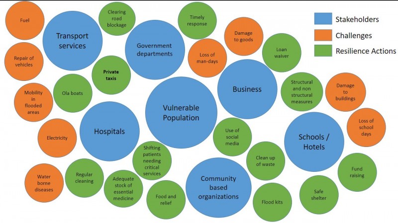
Resilience Efforts
Various segments of society assisted local communities and relief providers in affected parts of Chennai to cope with the flood. The Chennai government, private schools and the Parent Association were three strong pillars which supported victims in the aftermath of the flood. School children from Hosur made artefacts for sale at an art show to raise funds for a severely affected government school in Poonamallee. Another group of 15 teachers and 40 alumni of the TVS Academy School of Hosur, travelled to Chennai to help improve the infrastructure of Aringar Anna Government Girls Higher Secondary School, Poonamallee. These groups extended help in painting damaged walls, blackboards and building new toilets. During and post flood, government schools were used as relief camps where food and health issues were partially covered by government and parent association.
Various segments of society assisted local communities and relief providers in affected parts of Chennai to cope with the flood.
Private enterprises, such as restaurants, taxi service providers and automobile service centers, also joined hands with the government to provide relief to the flood affected population. Kolapasi, a Chennai-based restaurant, was turned into a temporary food relief agency. Social media was used for awareness generation on the initiative and also to raise funds. Individuals of all age groups and across all professions, supported this initiative by volunteering to cook, wash utensils, pack and deliver food. About 1.7 lakhs food boxes were distributed across the city.
The ride-hailing company Ola started operating boats, which also provided an important learning for future preparedness measures. They strategically identified water routes for providing service to even the most inaccessible areas. They also helped the Fire Department in conducting their rescue operations. Similarly, a vegetable and milk supply chain, Heritage Fresh, sold their commodities at a subsidized rate when prices in parts of Chennai were on the rise. Mobile vegetable shops also put in efforts to reach out to as many flood affected people as possible. Online food service providers, such as Zomato, added one extra meal on behalf of the company for every order that was placed for the stranded people.
The impact of flood on health sector was a complex issue, as the threats to health were both direct (for example, flash flood) and indirect (for example, a hospital needing to be closed due to flooding). To protect and promote health of patients and minimize health risks, sustained treatment for chronic infectious disease were provided through voluntary camps. 51 patients were evacuated and ICU wards were shifted to first floor; special care was taken while shifting new born babies, mental patients, elderly or patients with disabilities; cleanliness was ensured by internal experts using prescribed norms and dosage of chemicals and sump pumps were installed in hospitals to drain out water. Adequate stock of medicine, injections and IV fluids (intravenous) were available for continued medical care of the patients. Immediate actions in response to the flash flood situation from the ESIC was to direct all capacities of the existing health care system towards flood relief, prevention of disease outbreak, water disinfection and vigilance for future outbreaks.
Funds for energy and fuel supply were of least priority, but their demand was high in slums and remote areas where it was required for the survival of sick family members, the elderly and children. Organizations like Oxfam, provided support through the provision of energy and fuel supply to households. Private companies like Servals Pvt Ltd. initiated a similar program of providing specially designed rehabilitation kit, which included a kerosene stove, water filter, utensils, disinfectant, etc. to the slum dwellers, manual laborers and villagers in the worst hit areas, who were not covered under government programs. Along with the kit, training was also provided to ensure optimum utilization of the given products.
Small- and medium-sized enterprises (SMEs) suffered both direct (physical) and indirect (man-days/ sales) loss. They demanded government to provide interest free loans and delay their tax payment along with other repayments. SMEs took adequate measures to build resilience against future floods through installation of electrical points at a raised height and flood defense barriers within their premises, securing databases by using online recovery systems, etc.
Vehicle service stations, such as Harsha Toyota collected and repaired cars that broke down due to water logging. Company ordered its dealerships to take extra space for flood affected cars while insurance companies were asked to clear their claims on time. They also provided discounted service packages, such as completely waiving labor charges, and offering ten percent discounts on spare parts, roadside assistance, loyalty points of up to Rs. 20,000, 50 percent discounts on car renewal and an exchange bonus up to Rs. 30,000 to flood-affected areas. The 2015 Chennai flash flood made all the car companies (e.g., Toyota, BMW, Renault, Maruti, Hyundai, Nissan, etc.) rethink and develop more sustainable business continuity plan for production, maintenance and parking. Several online and local sellers including a number of automobile portals, such as Copart, has a separate page exclusively for cars damaged in Chennai floods for holding auctions.
Hotel authority liaised with local authorities (i.e., police and fire service and incorporated emergency plans and services wherever possible. Guests were relocated and although flood kits (water proof clothing, blanket, candle/torches, etc.) was provided to all, there is a need to strengthen response and relief capacity of hotels.
Community-Based Organizations (CBOs), such as Tamil Nadu Thowheed Jamath (TNTJ) mobilized over 700 volunteers for carrying out rescue, relief, rehabilitation and reconstruction work, which included arranging food, shelter, cleaning up after flood water resided, waste management, spraying of insecticides and distribution of relief kit. They used half-cut plastic tank boats to rescue stranded people, conducted community based training programmes in health risks and fostered behavioral changes to support all social groups. TNTJ also became one of the coordinating facilitator through establishment of community, zone and district level mechanism with local partners, frontline workers and line departments.
Social media, such as Facebook, Twitter, and Google Maps, played an important role in bringing all the service providers and individuals to work together for reducing the impact and helping the flood affected population recover better. These platforms helped disseminate information, broadcast further warnings, inform people of the undertaken initiatives, call for volunteers in respective sectors, crowdsource and map the waterlogged or inundated areas. Professor Amit Sheth and his team at Wright State University in the United States carried out a new National Science Fund (NSF)-funded project, the Social and Physical Sensing Enabled Decision Support for Disaster Management and Response. This technology was mobilized to monitor and analyze social media and crowdsourcing for better situational awareness of Chennai flood. Companies, such as BSNL, Paytm, Airtel and Zomato, also pitched in to help Chennai flood victims.
Towards Building Urban Disaster Risk Resilience
The 2015 Chennai flood caused by the torrential downpour brought city life to a standstill. It affected socio-economic condition of the district, maimed critical infrastructure, stranded animals and humans, disrupted services and flooded major parts of the city. The incorporation of flood preparedness measures will help reduce the extent of their impact on people, their life and property in future, along with giving them better coping abilities.
Best practices from Chennai flood case study should be used to strengthen existing risk handling capacities as well as learn lessons, to help replicate similar initiatives for preparedness of other Indian cities. This will also enable the government to coordinate and collaborate with similar service providers across the city for conducting efficient rescue and response operations in future. Best practices extrapolated from this case study could also prove useful to local and national officials from countries throughout Asia and the Middle East, all of whom continue to wrestle with the complex challenges associated with responding to responding to natural disasters in urban settings.
Prioritized interventions and emergency responses which can be used to reduce urban risk, redevelop city plans and ensure effective disaster relief operations in future are listed below.
➢ As was reflected in the initiatives undertaken by several CBOS, particularly TNTJ, disaster response should address the humanitarian imperative; adhere to the principles of neutrality and impartiality; and ensure local participation and accountability, along with respecting local culture and custom. Thus, awareness generation and capacity building programs should promote inclusive flood disaster management approaches. Operational and sustainable livelihood models should be developed in the aftermath of such emergencies for weaker sections of the society. Disaster resistant shelters, public buildings and critical infrastructure, such as water and sewerage networks, need to be improved in order to avoid water logging and enhance community resilience.
➢ Cities need to develop broadcasting systems to inform the affected community about real time extreme events in different locales and provide updates on current road, flood, weather, food and energy supply scenario. Social media helps develop a two-way communication which helps acquire real time information from the community itself.
➢ Development of city disaster risk resilience strategy will better enable government and non-government organizations in phasing out adaptation and mitigation measures during normalcy.
➢ To ensure community level disaster preparedness, designed trainings should include actions or steps to be taken by citizen prior to, during and after disaster scenarios. Emergency respondents need to have basic first aid skills, such as airway management, bleeding control and simple triage.
➢ Emotional impact of the event on both workers as well as victims need to be addressed and documented for informing city disaster management plan.
➢ GIS-based evacuation plans, including current flood water flow, emergency routes, water depth, obstacles and possible search and rescue (SAR) interventions, need to be prepared. Existing capacity needs to be strengthened and assistance programmes should be provided to existing or new SAR teams at district and state level, for future preparedness. In addition, there is also a need to prepare Flood Risk Maps highlighting availability of grocery stores, restaurants, public utilities, food storage units, hospitals, residential homes for elderly people, high flood prone areas, etc.
➢ Communication systems, including early warning and public awareness mechanisms, need to be established in order to disseminate information during adverse conditions. (There is also an urgent need to prioritize child protection for the prevention of child trafficking during disasters.)
➢ Adaptation strategies need to ensure raised utility and reduced food cost through development and strengthening of local food suppliers. Food supply chain should be maintained by improved coordination and efficiency between producers, suppliers and retailers.
➢ Local flood plain maps, should inform construction practices (e.g., selection of appropriate materials for walls and floors).
➢ In flood-prone areas, water proofing should be mandated for emergency facilities like- power control room, water treatment plants, sewerage plants, etc. Emergency food and assets (generator sets, fuel) area should be at an elevated level to prevent inundation due to flooding.
Note: The detailed assessment of interventions undertaken during and post Chennai floods was funded by Rockefeller Foundation under the Asian Cities Climate Change Resilience Network program. The study was conducted by Taru Leading Edge and IFMR Chennai.
[1] “Chennai Metropolitan Urban Region Population 2011 Census,” accessed May 29, 2017, http://www.census2011.co.in/census/metropolitan/435-chennai.html .
[2] Deepa H. Ramakrishnan, “Memories of Rain Ravaged Madras,” The Hindu, December 9, 2015, accessed May 29, 2017, http://www.thehindu.com/news/cities/chennai/floods-in-madras-over-years… .
[3] “Letter from Chennai- Saving a home from floods,” The National, January 17, 2015, accessed May 29, 2017, http://www.thenational.ae/world/south-asia/20151213/letter-fromchennai-saving-a-home-from-the-floods ; “When Chennai was logged out and how,” Deccan Chronicle, accessed March 29, 2017; and http://www.deccanchronicle.com/151203/nation-currentaffairs/article/when-chennai- was-logged-out-and-how.B. Narasimhan, “Storm water drainage of Chennai: Lacuna, Assets, and Way Forward.” Presentation made at “Resilient Chennai: Summit on Urban Flooding,” hosted by 100 Resilient Cities in partnership with the Corporation of Chennai (2016).
The Middle East Institute (MEI) is an independent, non-partisan, non-for-profit, educational organization. It does not engage in advocacy and its scholars’ opinions are their own. MEI welcomes financial donations, but retains sole editorial control over its work and its publications reflect only the authors’ views. For a listing of MEI donors, please click her e .
India: Managing the Complex Problem of Floods and Droughts

- Floods and droughts are on the rise in India. But they need not become disasters. It depends on how society manages them.
- The World Bank has put forward the EPIC Response framework to better manage these climate extremes. It emphasizes that floods and droughts be addressed as different ends of the same spectrum, and the whole of society be involved in the response – including the government, private sector, local government, academia, and civil society.
- The Framework is now being piloted in India’s flood-prone state of Assam, along with a new tool that enables various agencies to assess the status of their flood and drought protection programs, identify where collaboration can be enhanced, and track progress over time.
Floods and droughts have long been a part of life in India. Almost 150 years ago, the Ganga canal system was developed to bring water to farmers in the fertile upper Gangetic Plain. In southern India too, the early 20 th century Krishna Raja Sagar Dam and other systems helped manage floods and prevent crop failures.
Today, however, the challenges are of a different magnitude altogether. The monsoon has become more erratic and unpredictable, bringing extreme rainfall on the one hand and sudden drought on the other. Worryingly, India's drought-prone area has increased by 57 percent since 1997 1 , while instances of heavy rainfall have risen by almost 85 percent since 2012. This can have far-reaching impacts, affecting several generations.
To mitigate the impacts of floods and droughts, India has launched many policies and programs to improve water security and build climate resilience – several with World Bank support. This includes advances in technologies such as flood forecasting models, hydromet services and early warning systems, greater dam safety, and a national plan for disaster management. Even so, these measures, although laudable, will not be enough to address the scale of India’s water woes.

Importantly, floods and droughts don’t need to become disasters. It depends on how society manages these climatic extremes. While national governments tend to deal with them in a siloed manner, what is needed is a paradigm shift in the way these events are managed altogether. It is a complex problem that requires a multi-sectorial approach to reduce the risks and impacts.
Given the urgency of staying ahead of the changing climate, the World Bank, with support from Deltares, a Netherlands-based research institute, has put forward a new perspective to better manage these risks – the EPIC Response framework (Enable, Plan, Invest, Control).
The framework is being piloted by the World Bank supported Assam Integrated River Basin Management Program . The program seeks to reduce the vulnerability of Assam’s people to climate-related disasters and help the state develop its substantial water resources in an integrated and sustainable manner.
Speaking of the program, Mr. Bhaskar Das, Chief Technical Officer, Flood and River Erosion Management Agency of Assam (FREMAA) pointed out: “The Water Resources Department and the State Disaster Management authorities are working in close coordination and in an integrated manner.”

To demonstrate the applicability of the EPIC Response framework in other Indian states, a workshop, co-organized by the Indian Water Partnership and the World Bank , was held in New Delhi in April 2023. Various central government agencies, leading experts and a mix of states that face recurrent floods and droughts participated.
While these states - Assam, Bihar, Karnataka, Kerala and Odisha - face many common challenges, they have different climatic, economic, and social conditions. In Karnataka, for instance, around 20,000 water bodies have dried up and, in many districts, groundwater is depleting by the day. In Assam, on the other hand, where the mighty Brahmaputra flows, floods, riverbank erosion, and encroachment of riverine areas are the major challenges. In Bihar, too, where many rivers flow down from the mountains of Nepal carrying large sediment loads, more than 70 percent of the land is flood prone. What’s more, 28 out of Bihar’s 38 districts are affected by either floods or droughts, and sometimes by both every year.
The workshop underscored three key messages:
· Addressing floods and droughts as different ends of the same spectrum.
· Collaboration between various water agencies and presenting a joint government response to the challenge.
· Involving the whole of societ y in the response - private sector, local government, academia, and civil society.
Delivering his keynote address, Mr. Kushvinder Vohra, Chairman, Central Water Commission , stated: “Floods and droughts are one of the most pressing issues of our time.” Therefore, he stressed, it is essential to develop climate-resilient structural and non-structural solutions for effective water governance.
The newly developed EPIC Response Assessment Methodology (ERAM) tool that is being piloted in Assam was also presented at the workshop. The tool is a decision support system that enables various agencies to assess the status of their hydro-climatic risk management systems, identify areas where program components can be strengthened, ascertain where collaboration can be enhanced, and track progress over time. The results can facilitate a policy dialogue to generate a common understanding of their programs’ status, as well as the challenges and opportunities for enhancing flood and drought risk management systems.
Commenting on the relevance of the EPIC framework in the Indian context, Mr. A.B. Pandya, Secretary General, International Commission on Irrigation & Drainage , said: “The EPIC framework serves as a good guideline and benchmark against which the readiness of the individual region or subregion can be assessed.”
Outlining the complex situation in Bihar, Mr. Pravin Kumar from the Bihar State Disaster Management Authori ty (BSDMA) spoke about their mandate to develop disaster management policy, lay down guidelines, approve plans across departments, coordinate implementation of plans, recommend funds for mitigation measures and review measures taken. He said that the EPIC Response Framework and the ERAM tool will be useful to assess these measures.
[1] “Drought in Numbers”, United Nations Convention to Combat Desertification 2022.
The workshop, Improving Flood and Drought Governance: Applying the EPIC Response Framework, took place on April 28, 2023, in New Delh i.
This site uses cookies to optimize functionality and give you the best possible experience. If you continue to navigate this website beyond this page, cookies will be placed on your browser. To learn more about cookies, click here .

An official website of the United States government
The .gov means it’s official. Federal government websites often end in .gov or .mil. Before sharing sensitive information, make sure you’re on a federal government site.
The site is secure. The https:// ensures that you are connecting to the official website and that any information you provide is encrypted and transmitted securely.
- Publications
- Account settings
Preview improvements coming to the PMC website in October 2024. Learn More or Try it out now .
- Advanced Search
- Journal List
- Indian J Community Med
- v.37(3); Jul-Sep 2012
Disaster Management in Flash Floods in Leh (Ladakh): A Case Study
Preeti gupta.
Regimental Medical Officer, Leh, Ladakh, India
Anurag Khanna
1 Commanding Officer, Army Hospital, Leh, India
2 Registrar, Army Hospital, Leh, India
Background:
On August 6, 2010, in the dark of the midnight, there were flash floods due to cloud burst in Leh in Ladakh region of North India. It rained 14 inches in 2 hours, causing loss of human life and destruction. The civil hospital of Leh was badly damaged and rendered dysfunctional. Search and rescue operations were launched by the Indian Army immediately after the disaster. The injured and the dead were shifted to Army Hospital, Leh, and mass casualty management was started by the army doctors while relief work was mounted by the army and civil administration.
The present study was done to document disaster management strategies and approaches and to assesses the impact of flash floods on human lives, health hazards, and future implications of a natural disaster.
Materials and Methods:
The approach used was both quantitative as well as qualitative. It included data collection from the primary sources of the district collectorate, interviews with the district civil administration, health officials, and army officials who organized rescue operations, restoration of communication and transport, mass casualty management, and informal discussions with local residents.
234 persons died and over 800 were reported missing. Almost half of the people who died were local residents (49.6%) and foreigners (10.2%). Age-wise analysis of the deaths shows that the majority of deaths were reported in the age group of 25–50 years, accounting for 44.4% of deaths, followed by the 11–25-year age group with 22.2% deaths. The gender analysis showed that 61.5% were males and 38.5% were females. A further analysis showed that more females died in the age groups <10 years and ≥50 years.
Conclusions:
Disaster preparedness is critical, particularly in natural disasters. The Army's immediate search, rescue, and relief operations and mass casualty management effectively and efficiently mitigated the impact of flash floods, and restored normal life.
Introduction
In the midnight of August 6, 2010, Leh in Ladakh region of North India received a heavy downpour. The cloud burst occurred all of a sudden that caught everyone unawares. Within a short span of about 2 h, it recorded a rainfall of 14 inches. There were flash floods, and the Indus River and its tributaries and waterways were overflowing. As many as 234 people were killed, 800 were injured, and many went missing, perhaps washed away with the gorging rivers and waterways. There was vast destruction all around. Over 1000 houses collapsed. Men, women, and children were buried under the debris. The local communication networks and transport services were severely affected. The main telephone exchange and mobile network system (BSNL), which was the lifeline in the far-flung parts of the region, was completely destroyed. Leh airport was flooded and the runway was covered with debris, making it non-functional. Road transport was badly disrupted as roads were washed away and blocked with debris at many places. The civil medical and health facilities were also severely affected, as the lone district civil hospital was flooded and filled with debris.
Materials and Methods
The present case study is based on the authors’ own experience of managing a natural disaster caused by the flash floods. The paper presents a firsthand description of a disaster and its prompt management. The data was collected from the records of the district civil administration, the civil hospital, and the Army Hospital, Leh. The approach used was both quantitative as well as qualitative. It included data collection from the primary sources of the district collectorate, interviews with the district civil administration and army officials who organized rescue operations, restoration of communication, and transport, mass casualty management, and informal discussions with local residents.
Disaster management strategies
Three core disaster management strategies were adopted to manage the crisis. These strategies included: i) Response, rescue, and relief operations, ii) Mass casualty management, and iii) Rehabilitation.
Response, rescue, and relief operations
The initial response was carried out immediately by the Government of India. The rescue and relief work was led by the Indian Army, along with the State Government of Jammu and Kashmir, Central Reserve Police Force (CRPF), and Indo-Tibetan Border Police (ITBP). The Indian Army activated the disaster management system immediately, which is always kept in full preparedness as per the standard army protocols and procedures.
There were just two hospitals in the area: the government civil hospital (SNM Hospital) and Army Hospital. During the flash floods, the government civil hospital was flooded and rendered dysfunctional. Although the National Disaster Management Act( 1 ) was in place, with the government civil hospital being under strain, the applicability of the act was hampered. The Army Hospital quickly responded through rescue and relief operations and mass casualty management. By dawn, massive search operations were started with the help of civil authorities and local people. The patients admitted in the civil hospital were evacuated to the Army Hospital, Leh in army helicopters.
The runway of Leh airport was cleared up within a few hours after the disaster so that speedy inflow of supplies could be carried out along with the evacuation of the casualties requiring tertiary level healthcare to the Army Command Hospital in Chandigarh. The work to make the roads operational was started soon after the disaster. The army engineers had started rebuilding the collapsed bridges by the second day. Though the main mobile network was dysfunctional, the other mobile network (Airtel) still worked with limited connectivity in the far-flung areas of the mountains. The army communication system was the main and the only channel of communication for managing and coordinating the rescue and relief operations.
Mass casualty management
All casualties were taken to the Army Hospital, Leh. Severely injured people were evacuated from distant locations by helicopters, directly landing on the helipad of the Army Hospital. In order to reinforce the medical staff, nurses were flown in from the Super Specialty Army Hospital (Research and Referral), New Delhi, to handle the flow of casualties by the third day following the disaster. National Disaster Cell kept medical teams ready in Chandigarh in case they were required. The mortuary of the government civil hospital was still functional where all the dead bodies were taken, while the injured were handled by Army Hospital, Leh.
Army Hospital, Leh converted its auditorium into a crisis expansion ward. The injured started coming in around 0200 hrs on August 6, 2010. They were given first aid and were provided with dry clothes. A majority of the patients had multiple injuries. Those who sustained fractures were evacuated to Army Command Hospital, Chandigarh, by the Army's helicopters, after first aid. Healthcare staff from the government civil hospital joined the Army Hospital, Leh to assist them. In the meanwhile, medical equipment and drugs were transferred from the flooded and damaged government civil hospital to one of the nearby buildings where they could receive the casualties. By the third day following the disaster, the operation theatre of the government civil hospital was made functional. Table 1 gives the details of the patients admitted at the Army Hospital.
Admissions in the Army Hospital, Leh

The analysis of the data showed that majority of the people who lost their lives were mainly local residents (49.6%). Among the dead, there were 10.3% foreign nationals as well [ Table 2 ]. The age-wise analysis of the deaths showed that the majority of deaths were reported in the age group 26–50 years, accounting for 44.4% of deaths, followed by 11–25 year group with 22.2% deaths.
Number of deaths according to status of residence

The gender analysis showed that 61.5% were males among the dead, and 38.5% were females. A further analysis showed that more females died in <10 years and ≥50 years age group, being 62.5% and 57.1%, respectively [ Table 3 ].
Age and sex distribution of deaths

Victims who survived the disaster were admitted to the Army Hospital, Leh. Over 90% of them suffered traumatic injuries, with nearly half of them being major traumatic injuries. About 3% suffered from cold injuries and 6.7% as medical emergencies [ Table 4 ].
Distribution according to nature of casualty among the hospitalized victims

Rehabilitation
Shelter and relief.
Due to flash floods, several houses were destroyed. The families were transferred to tents provided by the Indian Army and government and non-government agencies. The need for permanent shelter for these people emerged as a major task. The Prime Minister of India announced Rs. 100,000 as an ex-gratia to the next of kin of each of those killed, and relief to the injured. Another Rs. 100,000 each would be paid to the next of kin of the deceased from the Chief Minister's Relief Fund of the State Government.
Supply of essential items
The Army maintains an inventory of essential medicines and supplies in readiness as a part of routing emergency preparedness. The essential non-food items were airlifted to the affected areas. These included blankets, tents, gum boots, and clothes. Gloves and masks were provided for the persons who were working to clear the debris from the roads and near the affected buildings.
Water, sanitation, and hygiene
Public Health is seriously threatened in disasters, especially due to lack of water supply and sanitation. People having lost their homes and living in temporary shelters (tents) puts a great strain on water and sanitation facilities. The pumping station was washed away, thus disrupting water supply in the Leh Township. A large number of toilets became non-functional as they were filled with silt, as houses were built at the foothills of the Himalayan Mountains. Temporary arrangements of deep trench latrines were made while the army engineers made field flush latrines for use by the troops.
Water was stagnant and there was the risk of contamination by mud or dead bodies buried in the debris, thus making the quality of drinking water questionable. Therefore, water purification units were installed and established. The National Disaster Response Force (NDRF) airlifted a water storage system (Emergency Rescue Unit), which could provide 11,000 L of pure water. Further, super-chlorination was done at all the water points in the army establishments. To deal with fly menace in the entire area, anti-fly measures were taken up actively and intensely.
Food and nutrition
There was an impending high risk of food shortage and crisis of hunger and malnutrition. The majority of food supply came from the plains and low-lying areas in North India through the major transport routes Leh–Srinagar and Leh–Manali national highways. These routes are non-functional for most part of the winter. The local agricultural and vegetable cultivation has always been scanty due to extreme cold weather. The food supplies took a further setback due to the unpredicted heavy downpour. Food storage facilities were also flooded and washed away. Government agencies, nongovernmental organizations, and the Indian Army immediately established food supply and distribution system in the affected areas from their food stores and airlifting food supplies from other parts of the country.
There was a high risk of water-borne diseases following the disaster. Many human bodies were washed away and suspected to have contaminated water bodies. There was an increased fly menace. There was an urgent need to prevent disease transmission due to contaminated drinking water sources and flies. There was also a need to rehabilitate people who suffered from crush injuries sustained during the disaster. The public health facilities, especially, the primary health centers and sub-health centers, were not adequately equipped and were poorly connected by roads to the main city of Leh. Due to difficult accessibility, it took many hours to move casualties from the far-flung areas, worsening the crisis and rescue and relief operations. The population would have a higher risk of mental health problems like post-traumatic stress disorder, deprivation, and depression. Therefore, relief and rehabilitation would include increased awareness of the symptoms of post-traumatic stress disorder and its alleviation through education on developing coping mechanisms.
Economic impact
Although it would be too early to estimate the impact on economy, the economy of the region would be severely affected due to the disaster. The scanty local vegetable and grain cultivation was destroyed by the heavy rains. Many houses were destroyed where people had invested all their savings. Tourism was the main source of income for the local people in the region. The summer season is the peak tourist season in Ladakh and that is when the natural disaster took place. A large number of people came from within India and other countries for trekking in the region. Because of the disaster, tourism was adversely affected. The disaster would have a long-term economic impact as it would take a long time to rebuild the infrastructure and also to build the confidence of the tourists.
The floods put an immense pressure and an economic burden on the local people and would also influence their health-seeking behavior and health expenditure.
Political context
The disaster became a security threat. The area has a high strategic importance, being at the line of control with China and Pakistan. The Indian Army is present in the region to defend the country's borders. The civil administration is with the Leh Autonomous Hill Development Council (LAHDC) under the state government of Jammu and Kashmir.
Conclusions
It is impossible to anticipate natural disasters such as flash floods. However, disaster preparedness plans and protocols in the civil administration and public health systems could be very helpful in rescue and relief and in reducing casualties and adverse impact on the human life and socio economic conditions.( 2 ) However, the health systems in India lack such disaster preparedness plans and training.( 3 ) In the present case, presence of the Indian Army that has standard disaster management plans and protocols for planning, training, and regular drills of the army personnel, logistics and supply, transport, and communication made it possible to immediately mount search, rescue, and relief operations and mass casualty management. Not only the disaster management plans were in readiness, but continuous and regular training and drills of the army personnel in rescue and relief operations, and logistics and communication, could effectively facilitate the disaster management operations.
Effective communication was crucial for effective coordination of rescue and relief operations. The Army's communication system served as an alternative communication channel as the public communication and mobile network was destroyed, and that enabled effective coordination of the disaster operations.
Emergency medical services and healthcare within few hours of the disaster was critical to minimize deaths and disabilities. Preparedness of the Army personnel, especially the medical corps, readiness of inventory of essential medicines and medical supplies, logistics and supply chain, and evacuation of patients as a part of disaster management protocols effectively launched the search, rescue, and relief operations and mass casualty reduction. Continuous and regular training and drills of army personnel, health professionals, and the community in emergency rescue and relief operations are important measures. Emergency drill is a usual practice in the army, which maintains the competence levels of the army personnel. Similar training and drill in civil administration and public health systems in emergency protocols for rescue, relief, mass casualty management, and communication would prove very useful in effective disaster management to save lives and restore health of the people.( 2 – 4 )
Lessons learnt and recommendations
Natural disasters not only cause a large-scale displacement of population and loss of life, but also result in loss of property and agricultural crops leading to severe economic burden.( 3 – 6 ) In various studies,( 3 , 4 , 7 , 8 ) several shortcomings have been observed in disaster response, such as, delayed response, absence of early warning systems, lack of resources for mass evacuation, inadequate coordination among government departments, lack of standard operating procedures for rescue and relief, and lack of storage of essential medicines and supplies.
The disaster management operations by the Indian Army in the natural disaster offered several lessons to learn. The key lessons were:
- Response time is a critical attribute in effective disaster management. There was no delay in disaster response by the Indian Army. The rescue and relief operations could be started within 1 h of disaster. This was made possible as the Army had disaster and emergency preparedness plans and protocols in place; stocks of relief supplies and medicines as per standard lists were available; and periodic training and drill of the army personnel and medical corps was undertaken as a routine. The disaster response could be immediately activated.
- There is an important lesson to be learned by the civil administration and the public health system to have disaster preparedness plans in readiness with material and designated rescue officers and workers.
- Prompt activation of disaster management plan with proper command and coordination structure is critical. The Indian Army could effectively manage the disaster as it had standard disaster preparedness plans and training, and activated the system without any time lag. These included standard protocols for search, rescue, and evacuation and relief and rehabilitation. There are standard protocols for mass casualty management, inventory of essential medicines and medical supplies, and training of the army personnel.
- Hospitals have always been an important link in the chain of disaster response and are assuming greater importance as advanced pre-hospital care capabilities lead to improved survival-to-hospital rate.( 9 ) Role of hospitals in disaster preparedness, especially in mass casualty management, is important. Army Hospital, Leh emergency preparedness played a major role in casualty management and saving human lives while the civil district hospital had become dysfunctional due to damage caused by floods. The hospital was fully equipped with essential medicines and supplies, rescue and evacuation equipments, and command and communication systems.
- Standard protocols and disaster preparedness plans need to be prepared for the civil administration and the health systems with focus on Quick Response Teams inclusive of healthcare professionals, rescue personnel, fire-fighting squads, police detachments, ambulances, emergency care drugs, and equipments.( 10 ) These teams should be trained in a manner so that they can be activated and deployed within an hour following the disaster. “TRIAGE” has to be the basic working principle for such teams.
- Effective communication system is of paramount importance in coordination of rescue and relief operations. In the present case study, although the main network with the widest connectivity was extensively damaged and severely disrupted, the army's communication system along with the other private mobile network tided over the crisis. It took over 10 days for reactivation of the main mobile network through satellite communication system. Thus, it is crucial to establish the alternative communication system to handle such emergencies efficiently and effectively.( 2 , 11 )
- Disaster management is a multidisciplinary activity involving a number of departments/agencies spanning across all sectors of development.( 2 ) The National Disaster Management Authority of India, set up under National Disaster Management Act 2005,( 1 ) has developed disaster preparedness and emergency protocols. It would be imperative for the civil administration at the state and district levels in India to develop their disaster management plans using these protocols and guidelines.
- Health system's readiness plays important role in prompt and effective mass casualty management.( 2 ) Being a mountainous region, the Ladakh district has difficult access to healthcare, with only nine Primary Health Centers and 31 Health Sub-Centers.( 12 ) There is a need for strengthening health systems with focus on health services and health facility network and capacity building. More than that, primary healthcare needs to be augmented to provide emergency healthcare so that more and more lives can be saved.( 7 )
- Training is an integral part of capacity building, as trained personnel respond much better to different disasters and appreciate the need for preventive measures. Training of healthcare professionals in disaster management holds the key in successful activation and implementation of any disaster management plan. The Army has always had standard drills in all its establishments at regular intervals, which are periodically revised and updated. The civil administration and public health systems should regularly organize and conduct training of civil authorities and health professionals in order to be ready for action.( 1 – 4 )
- Building confidence of the public to avoid panic situation is critical. Community involvement and awareness generation, particularly that of the vulnerable segments of population and women, needs to be emphasized as necessary for sustainable disaster risk reduction. Increased public awareness is necessary to ensure an organized and calm approach to disaster management. Periodic mock drills and exercise in disaster management protocols in the general population can be very useful.( 1 , 3 , 4 )
Source of Support: Nil
Conflict of Interest: None declared.
Advertisement
Urban floods in Hyderabad, India, under present and future rainfall scenarios: a case study
- Original Paper
- Published: 24 October 2018
- Volume 95 , pages 637–655, ( 2019 )
Cite this article
- Swathi Vemula 1 ,
- K. Srinivasa Raju 1 ,
- S. Sai Veena 1 &
- A. Santosh Kumar 1
2118 Accesses
30 Citations
32 Altmetric
Explore all metrics
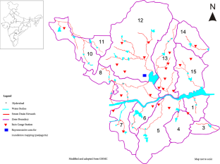
This study assesses and evaluates the impacts of future extreme rainfall event(s) on conveyance capacity of urban Storm Water Network (SWN) of Hyderabad City, India, along with flood risk analysis and inundation mapping. The catchment runoff volume was simulated using Storm Water Management Model (SWMM). The runoff simulations were carried out for historic and future extreme rainfall event(s). Future rainfall events were simulated under climate change scenarios using Global Climate Model (GCM), GFDL-CM3 of Coupled Model Intercomparison Project Phase 5 (CMIP5). Nonlinear regression-based statistical downscaling was used to obtain rainfall at regional scale for Representative Concentration Pathways (RCPs) 2.6, 4.5, 6.0 and 8.5. It was found that RCPs 2.6, 4.5, 6.0 and 8.5 predicted a future extreme rainfall of 693 mm, 431 mm, 282 mm and 564 mm for the years 2088, 2098, 2040 and 2068, respectively. SWMM results indicated that the future extreme rainfall in Hyderabad can result in increased runoff volumes causing flooding. The existing SWN was capable of handling RCP 6.0 with 82% runoff. However, it was inadequate to convey runoff from RCPs 2.6, 4.5 and 8.5. Modelling results suggest that the conveyance capacity of storm drains can be increased by 25–30% by desilting major drains and outlets.
This is a preview of subscription content, log in via an institution to check access.
Access this article
Price includes VAT (Russian Federation)
Instant access to the full article PDF.
Rent this article via DeepDyve
Institutional subscriptions
Agilan V, Umamahesh N (2015) Detection and attribution of non-stationarity in intensity and frequency of daily and 4-h extreme rainfall of Hyderabad. India J Hydrol 530:677–697
Article Google Scholar
Ahmed Z, Rao DRM, Reddy KRM, Raj YE (2013) Urban flooding-case study of Hyderabad global journal of engineering. Des Technol 2:63–66
Google Scholar
Akshara G, Srinivasa Raju K, Singh AP, Vasan A (2018) Application of multiple linear regression as downscaling methodology for lower Godavari basin. In: Singh V, Yadav S, Yadava R (eds) Climate change impacts. Water Science and Technology Library, vol 82. Springer, Singapore, pp 25–34. https://doi.org/10.1007/978-981-10-5714-4_3
Chapter Google Scholar
American Society of Civil Engineers (ASCE) (1992) Design and construction of urban stormwater management systems. American Society of Civil Engineers, New York
Anandhi A, Srinivas V, Nanjundiah RS, Nagesh Kumar D (2008) Downscaling precipitation to river basin in India for IPCC SRES scenarios using support vector machine. Int J Climatol 28:401–420
Assessment AR (2016) Chennai floods 2015. https://itra.medialabasia.in/img/Che0nnai%20Floods-Rapid%20Assessment%20Report-May%2023,%202016.pdf . Accessed on July 2018
Bi EG, Gachon P, Vrac M, Monette F (2017) Which downscaled rainfall data for climate change impact studies in urban areas? Rev Curr Approaches Trends Theor Appl Climatol 127:685–699
GHMC Disaster Management cell (2018) http://www.ghmc.gov.in/Disaster.aspx . Accessed on July 2018
Chatterjee M (2010) Slum dwellers response to flooding events in the megacities of India. Mitig Adapt Strat Glob Change 15:337–353
Chaturvedi RK, Joshi J, Jayaraman M, Bala G, Ravindranath N (2012) Multi-model climate change projections for India under representative concentration pathways. Curr Sci 103:791–802
Dahm RJ, Singh UK, Lal M, Marchand M, Sperna Weiland FC, Singh SK, Singh MP (2016) Downscaling GCM data for climate change impact assessments on rainfall: a practical application for the Brahmani-Baitarani river basin. Hydrol Earth Sys Sci. https://doi.org/10.5194/hess-2015-499
De Iorio M, Muller P, Rosner GL, MacEachern SN (2004) An ANOVA model for dependent random measures. J Am Stat As 99:205–215
Deccan Chronicle (2016) Hyderabad floods: 16.7 cm rain breaks 16-year-old record. https://www.deccanchronicle.com/nation/current-affairs/220916/hyderabad-floods-167-cm-rain-breaks-16-year-old-record.html . Accessed on Aug 2017
Deccan Chronicle (2017) Drainage shortage cripples Hyderabad. https://www.deccanchronicle.com/nation/current-affairs/070917/drainage-shortage-cripples-hyderabad.html . Accessed on Jan 2018
Delworth TL, Broccoli AJ, Rosati A, Stouffer RJ, Balaji V, Beesley JA, Cooke WF, Dixon KW, Dunne J, Dunne KA, Durachta JW (2006) GFDL’s CM2 global coupled climate models. Part I: formulation and simulation characteristics. J Clim 19:643–674
Denault C, Millar RG, Lence BJ (2006) Assessment of possible impacts of climate change in an urban catchment JAWRA. J Am Water Resour As 42:685–697
Diaz-Nieto J, Wilby RL (2005) A comparison of statistical downscaling and climate change factor methods: impacts on low flows in the River Thames, United Kingdom. Clim Change 69:245–268
Field CB, Barros VR (2014) IPCC, 2014: climate change 2014: impacts, adaptation, and vulnerability. Part A: global and sectoral aspects. Contribution of working group II to the fifth assessment report of the intergovernmental panel on climate change. Cambridge University Press, Cambridge, New York
Floodlist (2016) India—11 dead in Telangana floods, dams remain dangerously high. http://floodlist.com/asia/india-floods-telangana-september-2016 . Accessed on Jan 2018
Fowler HJ, Blenkinsop S, Tebaldi C (2007) Linking climate change modelling to impacts studies: recent advances in downscaling techniques for hydrological modelling. Int J Climatol 27:1547–1578
GHMC (2007) General information on drains of Hyderabad. Unpublished report
Google Earth v 6 (2016) Hyderabad, Telangana, India, 17.45 lat, 78.44 long at eye alt 35.16 miles. Accessed on May 2016
Gupta K (2007) Urban flood resilience planning and management and lessons for the future: a case study of Mumbai, India. Urb Water J 4:183–194
Harlow M, Prince G, Jones C, Tucker C, Reinhart J (2005) ArcGIS 9 geoprocessing commands quick reference guide. Environmental Science Research Institute, Redlands, California, p 175
Hashmi M, Shamseldin A, Melville B (2009) Statistical downscaling of precipitation: state-of-the-art and application of bayesian multi-model approach for uncertainty assessment. Hydrol Earth Syst Sci Dis 6:6535–6579
Hindustan times (2016) A repeat of 2000 floods: the four days Hyderabad stood still. https://www.hindustantimes.com/india-news/a-repeat-of-2000-floods-the-four-days-hyderabad-stood-still/story-ecWIeaJwyyZtQAGvRYQ4RN.html . Accessed on June 2018
Huizinga J, de Moel H, Szewczyk W (2017) Global flood depth-damage functions: Methodology and the database with guidelines. Joint Research Centre, Seville site
India Population (2017) http://indiapopulation2017.in/population-of-hyderabad-2017.html . Accessed on June 2018
Karamouz M, Nazif S (2013) Reliability-based flood management in urban watersheds considering climate change impacts. J Water Resour Plan Manag 139:520–533
Krebs G, Kokkonen T, Valtanen M, Koivusalo H, Setala H (2013) A high resolution application of a stormwater management model (SWMM) using genetic parameter optimization. Urb Water J 10(6):394–410
Land rate Telangana Registration (2017) http://registration.telangana.gov.in/ts/Unitrate.do . Accessed on Feb 2017
Latif M, Hannachi A, Syed F (2018) Analysis of rainfall trends over Indo-Pakistan summer monsoon and related dynamics based on CMIP5 climate model simulations. Int J Climatol 38:577–595
Livemint (2016) http://www.livemint.com/Politics/w9SiawKVG3Y0NDcXm6n84N/Heavy-rains-disrupt-normal-life-in-Andhra-Pradesh-many-trai.html . Accessed on July 2017
Lopes CL, Alves FL, Dias JM (2017) Flood risk assessment in a coastal lagoon under present and future scenarios: Ria de Aveiro case study. Nat Hazards 89:1307–1325
Martini F, Loat R (2010) Handbook on good practices for flood mapping in Europe. European exchange circle on flood mapping (EXCIMAP), Paris/Bern
Meenu R, Rehana S, Mujumdar P (2013) Assessment of hydrologic impacts of climate change in Tunga–Bhadra river basin, India with HEC-HMS and SDSM. Hydrol Process 27:1572–1589
Menon A, Levermann A, Schewe J, Lehmann J, Frieler K (2013) Consistent increase in Indian monsoon rainfall and its variability across CMIP-5 models. Earth Syst Dyn 4:287–300
Meyer V, Scheuer S, Haase D (2009) A multicriteria approach for flood risk mapping exemplified at the Mulde river, Germany. Nat Hazards 48:17–39
Mishra BK, Rafiei Emam A, Masago Y, Kumar P, Regmi RK, Fukushi K (2018) Assessment of future flood inundations under climate and land use change scenarios in the Ciliwung River Basin, Jakarta. J Flood Risk Manag 11:1105–1115
Mujumdar P, Kumar DN (2012) Floods in a changing climate: hydrologic modelling. Cambridge University Press, Cambridge
Book Google Scholar
NRSC (2017) Digital elevation model. http://bhuvan.nrsc.gov.in/bhuvan_links.php . Accessed on May 2016
Ojha C, Goyal MK, Adeloye A (2010) Downscaling of precipitation for lake catchment in arid region in India using linear multiple regression and neural networks. Open Hydrol J 4:122–136
Ongoma V, Chen H, Gao C (2018) Projected changes in mean rainfall and temperature over East Africa based on CMIP5 models. Int J Climatol 38:1375–1392
Pina R, Simoes N, Marques J, Sousa J (2011) Floodplain delineation with free and open source software. In: 12th International conference on urban drainage, Porto Alegre
Prudhomme C, Reynard N, Crooks S (2002) Downscaling of global climate models for flood frequency analysis: where are we now? Hydrol Process 16:1137–1150
Rai PK, Chahar B, Dhanya C (2017) GIS-based SWMM model for simulating the catchment response to flood events. Hydrol Res 48:384–394
Raje D, Mujumdar P (2011) A comparison of three methods for downscaling daily precipitation in the Punjab region. Hydrol Process 25:3575–3589
Raju KS, Sonali P, Kumar DN (2017) Ranking of CMIP5-based global climate models for India using compromise programming. Theor Appl Climatol 128:563–574
Ramachandraiah C, Prasad S (2004) Impact of urban growth on water bodies: the case of Hyderabad. Centre for Economic and Social Studies, Hyderabad
Ranger N, Hallegatte S, Bhattacharya S, Bachu M, Priya S, Dhore K, Rafique F, Mathur P, Naville N, Henriet F, Herweijer C (2011) An assessment of the potential impact of climate change on flood risk in Mumbai. Clim Change 104:139–167
Reshmidevi T, Kumar DN, Mehrotra R, Sharma A (2018) Estimation of the climate change impact on a catchment water balance using an ensemble of GCMs. J Hydrol 556:1192–1204
Rossman L, Huber W (2016) Storm water management model reference manual volume I—hydrology (revised). US Environmental Protection Agency, Cincinnati
Saaty TL (1977) A scaling method for priorities in hierarchical structures. J Math Psychol 15:234–281
Saharia AM, Sarma AK (2018) Future climate change impact evaluation on hydrologic processes in the Bharalu and Basistha basins using SWAT model. Nat Hazards 92:1463–1488
Sarala C, SreeLakshmi G (2014) Improvement of storm water drainage system in greater Hyderabad municipal corporation. Int J Adv Eng Technol 7(2):605
Srinivasa Raju K, Kumar DN (2018) Selection of global climate models. In: Impact of climate change on water resources. Springer Climate. Springer, Singapore, pp 27–75. https://doi.org/10.1007/978-981-10-6110-3_2
Sun DZ, Zhang T, Covey C, Klein SA, Collins WD, Hack JJ, Kiehl JT, Meehl GA, Held IM, Suarez M (2006) Radiative and dynamical feedbacks over the equatorial cold tongue: results from nine atmospheric GCMs. J Clim 19:4059–4074
Swathi V, Sai Veena S, Santosh A, Raju KS (2017) Urban floods under changing climate—a case study of Greater Hyderabad. In: American geophysical union international conference, New Orleans, Louisiana. http://fall-2017.vps.agu.org/media/77
Swathi V, Srinivasa Raju K, Singh AP (2018) Application of storm water management model to an urban catchment. In: Singh V, Yadav S, Yadava R (eds) Hydrologic modeling. Water Science and Technology Library, vol 81. Springer, Singapore, pp 175–184. https://doi.org/10.1007/978-981-10-5801-1_13
Tatli H, Nuzhet Dalfes H, Sibel Mentes S (2004) A statistical downscaling method for monthly total precipitation over Turkey. Int J Climatol 24:161–180
The Hindu (2017) Remodelling of drainage system may cost a bomb. http://www.thehindu.com/news/cities/Hyderabad/remodelling-of-drainage-system-may-cost-a-bomb/article19614139.ece . Accessed on May 2016
The Indian Express (2016) Heavy rain alert in Hyderabad; highways, railway tracks flooded. http://indianexpress.com/article/india/india-news-india/hyderabad-heavy-rain-alert-flodding-highway-railway-tracks-water-logging-3045215/ . Accessed on Sept 2017
The News Minute (2016) Rain and flooding in Hyderabad: What caused it and why both govt and people are responsible for it. https://www.thenewsminute.com/article/rain-and-flooding-hyderabad-what-caused-it-and-why-both-govt-and-people-are-responsible-it . Accessed on June 2018
The Times of India (2016) Hyderabad rain: Vehicle owners hit hard. https://timesofindia.indiatimes.com/city/hyderabad/Hyderabad-rain-Vehicle-owners-hit-hard/articleshow/54474659.cms . Accessed on Feb 2018
Tiwari PR, Kar S, Mohanty U, Kumari S, Sinha P, Nair A, Dey S (2014) Skill of precipitation prediction with GCMs over north India during winter season. Int J Climatol 34:3440–3455
Tripathi S, Srinivas V, Nanjundiah RS (2006) Downscaling of precipitation for climate change scenarios: a support vector machine approach. J hydrol 330:621–640
Vandana K, Islam A, Sarthi PP, Sikka, AK, Kapil H (2018) Assessment of potential impact of climate change on streamflow: a case study of the Brahmani River basin, India. J Water Clim Change. https://doi.org/10.2166/wcc.2018.129
Wan B, James W (2002) SWMM calibration using genetic algorithms. In: International conference on Global Solutions for Urban Drainage. American Society of Civil Engineers, pp 1–14. https://doi.org/10.1061/40644.92
Waters D, Watt WE, Marsalek J, Anderson BC (2003) Adaptation of a storm drainage system to accommodate increased rainfall resulting from climate change. J Environ Plan Manag 46:755–770
Wu C, Huang G, Yu H (2015) Prediction of extreme floods based on CMIP5 climate models: a case study in the Beijiang River basin, South China. Hydrol Earth Syst Sci 19:1385–1399
Zaghloul NA (1983) Sensitivity analysis of the SWMM runoff-transport parameters and the effects of catchment discretisation. Adv Water Resour 6:214–223
Zahmatkesh Z, Burian SJ, Karamouz M, Tavakol Davani H, Goharian E (2014) Low-impact development practices to mitigate climate change effects on urban stormwater runoff: case study of New York City. J Irrig Drain Eng 141:04014043
Download references
Acknowledgements
This work is supported by Information Technology Research Academy (ITRA), Government of India under, ITRA-water grant ITRA/15(68)/water/IUFM/01. Authors thank officials of Greater Hyderabad Municipal Corporation (GHMC) for providing storm water network data, brain storming discussions, valuable suggestions and facilitating for field surveys. Special acknowledgments to Mr D. Ravinder, Superintending Engineer, GHMC, for providing data and valuable thought provoking discussions. We acknowledge the World Climate Research Programme’s Working Group on Coupled Modelling, which is responsible for CMIP5, and we thank the climate modelling groups for producing and making their model output available. For CMIP, the US Department of Energy’s Program for Climate Model Diagnosis and Intercomparison provides coordinating support and led development of software infrastructure in partnership with the Global Organisation for Earth System Science Portals. We thank the India Meteorological Department (IMD) and National Centers for Environmental Prediction (NCEP) for providing rainfall data. We thank United States Environmental Protection Agency (US EPA) for making Storm Water Management Model (SWMM) an open source software, and authors also thank Google Earth for its open source images. We extend special acknowledgments to Dr Murari RR Varma, Prof D.Nagesh Kumar and Prof N. V. Umamahesh for suggesting improvements in the manuscript.
Author information
Authors and affiliations.
Department of Civil Engineering, Birla Institute of Technology and Science, Pilani-Hyderabad Campus, Hyderabad, 500078, India
Swathi Vemula, K. Srinivasa Raju, S. Sai Veena & A. Santosh Kumar
You can also search for this author in PubMed Google Scholar
Corresponding author
Correspondence to Swathi Vemula .
Rights and permissions
Reprints and permissions
About this article
Vemula, S., Raju, K.S., Veena, S.S. et al. Urban floods in Hyderabad, India, under present and future rainfall scenarios: a case study. Nat Hazards 95 , 637–655 (2019). https://doi.org/10.1007/s11069-018-3511-9
Download citation
Received : 20 February 2018
Accepted : 04 October 2018
Published : 24 October 2018
Issue Date : 15 February 2019
DOI : https://doi.org/10.1007/s11069-018-3511-9
Share this article
Anyone you share the following link with will be able to read this content:
Sorry, a shareable link is not currently available for this article.
Provided by the Springer Nature SharedIt content-sharing initiative
- Climate change
- Extreme rainfall events
- Representative concentration pathways
- Storm water management model
- Urban floods
- Find a journal
- Publish with us
- Track your research
- Personal Finance
- New CNBC-TV18 Accelerate
- New AI Alliance Pune
- New Election Exchange
- New SME Champion Awards
- New Latest News
- Live Market Live
CNBC-TV18 Specials
- Young Turks
- Mind Matters
- Climate Clock
- Marquee Nights
- Future Female Forward
- 11:11 Newsletter
- Global Markets
- Cryptocurrency
Terms and Conditions
- Terms of Use
- Privacy Policy
The worst floods in India — from Mumbai to Uttarakhand to now Assam under water
Floods are the most common natural disaster in India. From the July 26, 2005, killer Mumbai floods to the ongoing situation in Assam, the country has witnessed many water-related catastrophes over the years. Climate change of course has a role to play in these ever-increasing events. Here’s a look at the worst floods India has seen over the past few years.

By CNBCTV18.com Jun 24, 2022 8:37:42 PM IST (Updated)

2013 Uttarakhand floods | The state of Uttarakhand, between June 13 and 17 2013, received extremely heavy rainfall that led to the melting of the Chorabari glacier and the eruption of the Mandakini river. The heavy rainfall caused massive flash floods and landslides resulting in the death of more than 5,000 residents and tourists. (Image: News18 Creative)

2007 Bihar floods | The August 2007 flooding had submerged more than 40 percent of Bihar. The floods affected 19 districts, more than 4822 villages and 10,000,000 hectares of farm land. The United Nations described it as the worst flood in Bihar. (Image: News18 Creative)

2005 Mumbai floods | 26 July 2005 is a date when Mumbai, the city that never sleeps, came to a halt. The city received a rainfall of 944 mm, a 100-year high, in a span of 24 hours. Thousands of people were stranded, at least 1,000 people lost their lives, and 14,000 homes were destroyed. (Image: News18 Creative)

2015 Tamil Nadu floods | Incessant heavy rains in late November and December 2015, brought life in Tamil Nadu to a standstill. The heavy downpour triggered massive floods affecting an estimated 1.8 million people with at least 470 people being killed. More than 40,000 were displaced in the deluge. (Image: News18 Creative)

2018 Kerala floods | The unprecedented heavy rains in 2018 led to the worst flooding in the state of Kerala since 1924. The floods killed over 400 people and displaced a million more. (Image: News18 Creative)

2014 Jammu & Kashmir floods | Jammu and Kashmir experienced heavy monsoon rains for over a week in September 2014 which led to widespread flooding and landslides across the state. Significant portions of Anantnag, Kulgam, Pulwama, Baramulla, Bandipora and Srinagar districts were submerged in water. (Image: News18 Creative)

2021 Maharashtra floods | The 2021 floods in Maharashtra killed around 251 people with hundreds missing. The torrential rain and landslides affected 13 districts with Raigad being the worst affected. (Image: News18 Creative)

2017 Gujarat floods |Gujarat in July 2017 received around 68 percent more rainfall than the average July, triggering floods that paralysed the state. Over 200 lives were lost in the floods. (Image: News18 Creative)

2021 Uttarakhand floods | Also known as the Chamoli disaster, the 2021 Uttarakhand floods were caused by a portion of the Nanda Devi glacier breaking off and releasing the water trapped behind the ice. The glacier burst generated a sudden flood killing over 200 people or missing. (Image: News18 Creative)

2006 Surat floods | The sudden release of a large amount of water into the Tapti River from the Ukai Dam led to 80 percent of Surat being flooded. The heavy outflow of about 900,000 cfs for a prolonged period of time caused the flood in Surat and other downstream villages. The high tide of the sea during the flood further reduced the drainage capacity of the river and worsened the damage due to flooding. (Image: News18 Creative)

2017 Assam floods | Assam is no stranger to monsoon floods. The incessant rains in 2017 resulted in, both the Brahmaputra and the Barak rivers, flowing above the danger mark and a flood alert was sounded in at least 15 districts in lower Assam. (Image: News18 Creative)

2012 Brahmaputra floods | The 2012 floods along the Brahmaputra River killed 120 people and about six million people were displaced. Assam was the worst affected area. The flooding severely impacted the Kaziranga National Park, where 540 animals died including 16 rhinos. (Image: News18 Creative)

2022 Assam floods | The floods in Assam have so far killed over 100 people with 55 lakh people being affected across 32 districts The army and NDRF teams are conducting evacuation operations and assisting those who are affected. (Image: News18 Creative)
Share Market Live
IMAGES
VIDEO
COMMENTS
Effects. In some areas, floodwater was between 3-4.5m deep. Floods in the southern Indian state of Kerala have killed more than 410 people since June 2018 in what local officials said was the worst flooding in 100 years. Many of those who died had been crushed under debris caused by landslides.
Specifically in this project, we study the "KeralaGram" group on Telegram, which had 15,000 users at the time of the 2018 flood and was focused on issues/events/news related to the state of Kerala. While Twitter has been extensively used for social sensing, the use of Telegram is less common. Most relevant Telegram research involves either ...
In November-December 2015 Chennai and its neighboring coastal districts in India experienced torrential rainfall followed by a devastating flood. Amid the chaos and widespread impact, the event brought people and institutions in and outside Chennai together, to provide support to the victims affected by the flood. Help reached the affected areas and their residents from different sections of ...
Some researchers say similar conditions may have loosed floods that killed 3,000 people in Pakistan and northern India in the summer of 2010. Several recent research papers say that global warming may have set up Kednarath for the disaster, by transforming regional weather patterns and eroding Chorabari Glacier.
That has resulted in one of the worst floods ever recorded in Assam. As of 3 July, flood has affected 1,835,551 people in 26 out of the state's 35 districts and it submerged 471.98 square kilometers (47,198.87 hectares) of cropland. [1] About 200 people have died so far. Earlier on 22 June the floods had affected 5,457,601 people in 32 ...
India has very high exposure to flooding including riverine, flash and coastal flooding. It has been a recurrent phenomenon in India and causes huge losses to lives, properties, livelihoods systems, infrastructure and public utilities. Out of the total geographical area of 329 mha, more than 40 mha is flood prone. The deadliest flooding
1. Introduction. Whenever drainage is mentioned in India, the well-planned gravity drainage system in the cities of the Indus Valley civilization (approx. 2500 BC) is cited, for example, Mohenjo-Daro (now in Pakistan) and Lothal (Gujarat, India) [1,2].Present-day India comprises 28 States and 9 Union Territories with an urban population of 377 million as reported in the 2011 census [] and this ...
Statistical data show that 23 major flood events from 1947 to 2015 in Pakistan resulted in a financial loss of USD 38.165 billion, over 12,000 casualties reported, and an affected land area of ...
Rashiq A and Prakash O (2023) Urban Floods: A Case Study of Patna Floods 2019 - Natural or Anthropogenic? Impacts of Urbanization on Hydrological Systems in India, 10.1007/978-3-031-21618-3_4, (57-78), .
The dam authorities probably found it necessary to release some water within a short span of time to accommodate the storm waters expected to be received from the cyclonic system that passed through the upper ... Priya T (2001) Development strategies for flood prone areas, case study: Patna. India Disaster Prev Manag 10(2):101-109. Article ...
To mitigate the impacts of floods and droughts, India has launched many policies and programs to improve water security and build climate resilience - several with World Bank support. These include advances in technologies such as flood forecasting models, hydromet services and early warning systems, improving dam safety, and a national plan for disaster management.
The present paper attempts to study the devastating floods that hit Chennai city during November-December 2015 and have claimed more than 400 lives (including other parts of Tamil Nadu) and caused enormous economic damages. The focus mainly is on flood routing through channels and reservoir, flood control and reservoir operation.
In India, many flood modeling studies have been carried out to understand the evolution of floods in order to manage the floods effectively. To understand the magnitude of damage to bridges during floods, Mazumdar (2009) evaluated hydrologic, topographic, and morphological characteristics of rivers to derive a relationship between the damage ...
On August 6, 2010, in the dark of the midnight, there were flash floods due to cloud burst in Leh in Ladakh region of North India. It rained 14 inches in 2 hours, causing loss of human life and destruction. The civil hospital of Leh was badly damaged and rendered dysfunctional. Search and rescue operations were launched by the Indian Army ...
Some of the recent case studies about Chennai floods of December 2015 investigated the impact of climate change based on extreme rainfall data and the relationship with the global phenomenon like El-Nino and La-Nina, but the observations are contrary because of different data sets and methodologies for analysis (Krishnamurthy et al. 2018; Boyaj ...
Even in the few years of the present century, India has suffered from floods of unprecedented di~nensidns, Here in this Unit, we shall describe and discuss three typical. Flood: Case Studies 47 cases; one of widespread riverine floods in the Gangetic Plain and the other of the flood devastation in the commercial capital of the country due to ...
View. Show abstract. ... The worldwide spatial distribution of flood events is depicted in Figure 22.2. Every year, nearly 8 million hectares of land is affected by floods in India (Ray et al ...
Urban flooding is significantly different from rural flooding as urbanisation leads to developed catchments which increases the flood peaks from 1.8 to 8 times and flood volumes by up to 6 times. Consequently, flooding occurs very quickly due to faster flow times, sometimes in a matter of minutes. Urban areas are centers of economic activities with vital infrastructure which needs to be ...
38. Areas affected. North India. Heavy rainfall during the 2023 monsoon season resulted in severe flooding and landslides across Northern India, primarily affecting residents in Himachal Pradesh, Punjab, Chandigarh, Uttarakhand, Jammu and Kashmir, Haryana, Rajasthan and Delhi. [1] [2] [3]
This study assesses and evaluates the impacts of future extreme rainfall event(s) on conveyance capacity of urban Storm Water Network (SWN) of Hyderabad City, India, along with flood risk analysis and inundation mapping. The catchment runoff volume was simulated using Storm Water Management Model (SWMM). The runoff simulations were carried out for historic and future extreme rainfall event(s ...
The United Nations described it as the worst flood in Bihar. (Image: News18 Creative) Floods are the most common natural disaster in India. From the July 26 floods in Mumbai to the on-going floods in Assam, the country has witnessed many disastrous floods over the years. Climate change has also played an important role in causing large-scale ...
Climate change has caused increased heat, drought, and insect outbreaks. In turn, these changes have made wildfires more numerous and severe. The warming climate has also caused a decline in water supplies, reduced agricultural yields, and triggered heat-related health impacts in cities. In coastal areas, flooding and erosion are additional ...