- 0 Shopping Cart

Eyjafjallajokull Case Study
What is Eyjafjallajokull?
Eyjafjallajokull is a volcano located in Iceland. The name is a description of the volcano with Eyja meaning island; fjalla meaning mountain; and jokull meaning glacier. You can find out how to pronounce Eyjafjallajokull on the BBC website .
Eyjafjallajökull consists of a volcano completely covered by an ice cap. The ice cap covers an area of about 100 square kilometres (39 sq mi), feeding many outlet glaciers.

What type of volcano is Eyjafjallajokull?
The mountain itself, a composite (stratovolcano) volcano, stands 1,651 metres (5,417 ft) at its highest point and has a crater 3–4 kilometres (1.9–2.5 mi) in diameter, open to the north.
When did Eyjafjallajokull erupt?
Eyjafjallajokull erupted between March and May 2010.
Why did Eyjafjallajokull erupt?
Iceland lies on the Mid-Atlantic Ridge, a constructive plate margin separating the North American and Eurasian plates. The two plates move apart due to ridge push along the Mid-Atlantic Ridge. As the plates move apart, magma fills the magma chamber below Eyjafjallajokull—several magma chambers combined to produce a significant volume of magma below the volcano. Eyjafjallajokull is located below a glacier.
The Eyjafjallajökull volcano erupted in 920, 1612 and again from 1821 to 1823 when it caused a glacial lake outburst flood (or jökulhlaup). It erupted three times in 2010—on 20 March, April–May, and June. The March event forced a brief evacuation of around 500 local people. Still, the 14 April eruption was ten to twenty times more powerful and caused substantial disruption to air traffic across Europe. It caused the cancellation of thousands of flights across Europe and to Iceland.
How big was the eruption of Eyjafjallajokull?
The eruption was only three on the volcanic explosivity index (VEI). Around 15 eruptions on this scale usually happen each year in Iceland. However, in this case, a combination of a settled weather pattern with winds blowing towards Europe, very fine ash and a persistent eruption lasting 39 days magnified the impact of a relatively ordinary event. The eruptions in March were mainly lava eruptions. On 14 April, a new phase began, which was much more explosive. Violent eruptions belched huge quantities of ash into the atmosphere.

The eruption of Eyjafjallajokull
What were the impacts of the eruption? (social / economic / environmental – primary and secondary effects)
Primary effects : As a result of the eruption, day turned to night, with the ash blocking the sun. Rescuers wore face masks to prevent them from choking on ash clouds.
Homes and roads were damaged, services were disrupted, crops were destroyed by ash, and roads were washed away. The ash cloud brought European airspace to a standstill during the latter half of April 2010 and cost billions of euros in delays. During the eruption, a no-fly zone was imposed across much of Europe, meaning airlines lost around £130m per day. The price of shares in major airlines dropped between 2.5 and 3.3% during the eruption. However, it should be noted that imports and exports are being impacted across European countries on the trade front, so the net trade position was not affected markedly overall.
Secondary effects : Sporting events were cancelled or affected due to cancelled flights. Fresh food imports stopped, and industries were affected by a lack of imported raw materials. Local water supplies were contaminated with fluoride. Flooding was caused as the glacier melted.
International Effects: The impact was felt as far afield as Kenya, where farmers have laid off 5000 workers after flowers and vegetables were left rotting at airports. Kenya’s flower council says the country lost $1.3m a day in lost shipments to Europe. Kenya exports typically up to 500 tonnes of flowers daily – 97% of which is delivered to Europe. Horticulture earned Kenya 71 billion shillings (£594m) in 2009 and is the country’s top foreign exchange earner. You can read more about this on the Guardian website .
What opportunities did the eruption of Eyjafjallajokull bring?
Despite the problems caused by the eruption of Eyjafjallajokull, the eruption brought several benefits. According to the Environmental Transport Association, the grounding of European flights prevented some 2.8 million tonnes of carbon dioxide into the atmosphere (according to the Environmental Transport Association).
As passengers looked for other ways to travel than flying, many different transport companies benefited. There was a considerable increase in passenger numbers on Eurostar. It saw a rise of nearly a third, with 50,000 extra passengers travelling on their trains.
Ash from the Eyjafjallajökull volcano deposited dissolved iron into the North Atlantic, triggering a plankton bloom, driving an increase in biological productivity.
Following the negative publicity of the eruption, the Icelandic government launched a campaign to promote tourism . Inspired by Iceland was established with the strategic intent of depicting the country’s beauty, the friendliness of its people and the fact that it was very much open for business. As a result, tourist numbers increased significantly following the campaign, as shown in the graph below.

Foreign visitor arrivals to Iceland
What was done to reduce the impact of the eruption of Eyjafjallajokull?
In the short term, the area around the volcano was evacuated.
European Red Cross Societies mobilised volunteers, staff and other resources to help people affected directly or indirectly by the eruption of the Eyjafjallajökull glacier volcano. The European Red Cross provided food for the farming population living in the vicinity of the glacier, as well as counselling and psychosocial support, in particular for traumatised children. Some 700 people were evacuated from the disaster zone three times in the past month. In one instance, people had to flee their homes in the middle of the night to escape from flash floods.
The European Union has developed an integrated structure for air traffic management. As a result, nine Functional Airspace Blocks (FABs) will replace the existing 27 areas. This means following a volcanic eruption in the future, areas of air space may be closed, reducing the risk of closing all European air space.

Premium Resources
Please support internet geography.
If you've found the resources on this page useful please consider making a secure donation via PayPal to support the development of the site. The site is self-funded and your support is really appreciated.
Related Topics
Use the images below to explore related GeoTopics.
Previous Topic Page
Topic home, sunda strait tsunami indonesia case study 2018, iconbox title.
Click to add your own text here
Share this:
- Click to share on Twitter (Opens in new window)
- Click to share on Facebook (Opens in new window)
- Click to share on Pinterest (Opens in new window)
- Click to email a link to a friend (Opens in new window)
- Click to share on WhatsApp (Opens in new window)
- Click to print (Opens in new window)
If you've found the resources on this site useful please consider making a secure donation via PayPal to support the development of the site. The site is self-funded and your support is really appreciated.
Search Internet Geography
Top posts and pages.
Latest Blog Entries
Pin It on Pinterest
- Click to share
- Print Friendly
Thank you for visiting nature.com. You are using a browser version with limited support for CSS. To obtain the best experience, we recommend you use a more up to date browser (or turn off compatibility mode in Internet Explorer). In the meantime, to ensure continued support, we are displaying the site without styles and JavaScript.
- View all journals
- Explore content
- About the journal
- Publish with us
- Sign up for alerts
- Published: 17 November 2010
Intrusion triggering of the 2010 Eyjafjallajökull explosive eruption
- Freysteinn Sigmundsson 1 ,
- Sigrún Hreinsdóttir 1 ,
- Andrew Hooper 2 ,
- Thóra Árnadóttir 1 ,
- Rikke Pedersen 1 ,
- Matthew J. Roberts 3 ,
- Níels Óskarsson 1 ,
- Amandine Auriac 1 ,
- Judicael Decriem 1 ,
- Páll Einarsson 1 ,
- Halldór Geirsson 3 ,
- Martin Hensch 1 ,
- Benedikt G. Ófeigsson 1 ,
- Erik Sturkell 4 ,
- Hjörleifur Sveinbjörnsson 3 &
- Kurt L. Feigl 5
Nature volume 468 , pages 426–430 ( 2010 ) Cite this article
8663 Accesses
321 Citations
25 Altmetric
Metrics details
- Environmental sciences
- Volcanology
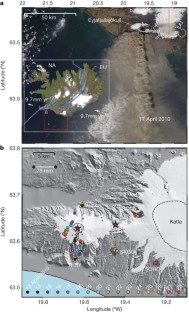
Gradual inflation of magma chambers often precedes eruptions at highly active volcanoes. During such eruptions, rapid deflation occurs as magma flows out and pressure is reduced 1 , 2 , 3 . Less is known about the deformation style at moderately active volcanoes, such as Eyjafjallajökull, Iceland, where an explosive summit eruption of trachyandesite beginning on 14 April 2010 caused exceptional disruption to air traffic, closing airspace over much of Europe for days. This eruption was preceded by an effusive flank eruption of basalt from 20 March to 12 April 2010. The 2010 eruptions are the culmination of 18 years of intermittent volcanic unrest 4 , 5 , 6 , 7 , 8 , 9 . Here we show that deformation associated with the eruptions was unusual because it did not relate to pressure changes within a single magma chamber. Deformation was rapid before the first eruption (>5 mm per day after 4 March), but negligible during it. Lack of distinct co-eruptive deflation indicates that the net volume of magma drained from shallow depth during this eruption was small; rather, magma flowed from considerable depth. Before the eruption, a ∼ 0.05 km 3 magmatic intrusion grew over a period of three months, in a temporally and spatially complex manner, as revealed by GPS (Global Positioning System) geodetic measurements and interferometric analysis of satellite radar images. The second eruption occurred within the ice-capped caldera of the volcano, with explosivity amplified by magma–ice interaction. Gradual contraction of a source, distinct from the pre-eruptive inflation sources, is evident from geodetic data. Eyjafjallajökull’s behaviour can be attributed to its off-rift setting with a ‘cold’ subsurface structure and limited magma at shallow depth, as may be typical for moderately active volcanoes. Clear signs of volcanic unrest signals over years to weeks may indicate reawakening of such volcanoes, whereas immediate short-term eruption precursors may be subtle and difficult to detect.
This is a preview of subscription content, access via your institution
Access options
Subscribe to this journal
Receive 51 print issues and online access
$199.00 per year
only $3.90 per issue
Buy this article
- Purchase on Springer Link
- Instant access to full article PDF
Prices may be subject to local taxes which are calculated during checkout
Southward growth of Mauna Loa’s dike-like magma body driven by topographic stress
Bhuvan Varugu & Falk Amelung

Precursor-free eruption triggered by edifice rupture at Nyiragongo volcano
D. Smittarello, B. Smets, … A. Syavulisembo Muhindo

Deformation and seismicity decline before the 2021 Fagradalsfjall eruption
Freysteinn Sigmundsson, Michelle Parks, … Thorbjörg Ágústsdóttir
Dzurisin, D. Volcano Deformation (Springer, 2007)
Google Scholar
Amelung, F., Jónsson, S., Zebker, H. & Segall, P. Widespread uplift and trapdoor faulting on Galápagos volcanoes observed with radar interferometry. Nature 407 , 993–996 (2000)
Article CAS ADS Google Scholar
Sigmundsson, F. Iceland Geodynamics: Crustal Deformation and Divergent Plate Tectonics (Springer, 2006)
Pedersen, R. & Sigmundsson, F. InSAR based sill model links spatially offset areas of deformation and seismicity for the 1994 unrest episode at Eyjafjallajökull volcano, Iceland. Geophys. Res. Lett. 31 L14610 10.1029/2004GL020368 (2004)
Article ADS Google Scholar
Pedersen, R. & Sigmundsson, F. Temporal development of the 1999 intrusive episode in the Eyjafjallajökull volcano, Iceland, derived from InSAR images. Bull. Volcanol. 68 , 377–393 (2006)
Hooper, A., Pedersen, R. & Sigmundsson, F. in The VOLUME Project — Volcanoes: Understanding Subsurface Mass Movement (eds Bean, C. J. et al.) 13–24 (University College Dublin, 2009)
Sturkell, E., Sigmundsson, F. & Einarsson, P. Recent unrest and magma movements at Eyjafjallajokull and Katla Volcanoes, Iceland. J. Geophys. Res. 108 2369 10.1029/2001JB000917 (2003)
Sturkell, E. et al. Katla and Eyjafjallajökull Volcanoes. Dev. Quat. Sci. 13 , 5–21 (2010)
Hooper, A. A multi-temporal InSAR method incorporating both persistent scatterer and small baseline approaches. Geophys. Res. Lett. 35 L16302 10.1029/2008GL034654 (2008)
Oskarsson, N., Sigvaldason, G. E. & Steinthórsson, S. A dynamic model of rift zone petrogenesis and the regional petrology of Iceland. J. Petrol. 23 , 28–74 (1985)
Larsen, G., Dugmore, A. J. & Newton, A. J. Geochemistry of historical-age silicic tephras in Iceland. Holocene 9 , 463–471 (1999)
Hjaltadottir, S. & Vogfjord, K. Seismic evidence of magma transport in Eyjafjallajökull during 2009–2010. Eos 91 (Fall meet. suppl) (abstract V21F-02)
Gudmundsson, M. T. et al. The Eyjafjallajökull eruption in April-May 2010; course of events, ash generation and ash dispersal. Eos 91 (Fall meet. suppl.) (abstract V53F-01)
Eineder, M. & Fritz, T. TerraSAR-X Ground Segment Basic Product Specification Document TX-GS-DD-3302 (DLR, 2009)
Okada, Y. Internal deformation due to shear and tensile faults in a half-space. Bull. Seismol. Soc. Am. 82 , 1018–1040 (1992)
Fialko, Y., Khazan, Y. & Simons, M. Deformation due to a pressurized horizontal circular crack in an elastic half-space, with applications to volcano geodesy. Geophys. J. Int. 146 , 181–190 (2001)
Hooper, A., Segall, P. & Zebker, H. Persistent scatterer interferometric synthetic aperture radar for crustal deformation analysis, with application to Volcan Alcedo, Galapagos. J. Geophys. Res. 112 B07407 10.1029/2006JB004763 (2007)
Hjaltadóttir, S., Vogfjörð, K. S. & Slunga, R. Seismic Signs of Magma Pathways Through the Crust in the Eyjafjallajökull Volcano, South Iceland . (Icelandic Meteorological Office report VÍ 2009-13, 2009)
Vogfjörd, K. S., Hjaltadóttir, S., Kjartansson, E. & Roberts, M. J. in The VOLUME Project — Volcanoes: Understanding Subsurface Mass Movement (eds Bean, C. J. et al.) 237–249 (University College Dublin, 2009)
Taisne, B. & Jaupart, C. Dike propagation through layered rocks. J. Geophys. Res. 114 B09203 10.1029/2008JB006228 (2009)
Sigmarsson O, Vlastelic, I. & Devidal, J. Trace-element variations reveal dynamic magma mixing during the 2010 eruption of Eyjafjallajökull, Iceland. Eos 91 (Fall meet. suppl.) (abstract V21F-04)
Eichelberger, J. C., Izbekov, P. E. & Browne, B. L. Bulk chemical trends at arc volcanoes are not liquid lines of descent. Lithos 87 , 135–154 (2006)
Marsh, B. A magmatic mush column Rosetta Stone: The McMurdo Dry Valleys of Antarctica. Eos 47 , 497–508 (2004)
Hreinsdóttir, S. & Bennett, R. A. Active aseismic creep on the Alto Tiberina low-angle normal fault, Italy. Geology 37 , 683–686 (2009)
Kampes, B., Hanssen, R. F. & Zbigniew, P. Radar interferometry with public domain tools. In Proceedings ‘Fringe 2003 Workshop’ (ESA SP-550, European Space Agency, 2004)
Jakobsdóttir, S. S. Seismicity in Iceland: 1994–2007. Jökull 58 , 75–100 (2008)
Hooper, A. et al. Is magma generated due to retreating ice caps, likely to erupt? Constraints on lower-crustal stress in Iceland from InSAR. In Proceedings ‘Fringe 2009 Workshop’ (ESA SP-677, European Space Agency, 2010)
Yun, S., Segall, P. & Zebker, H. Constraints on magma chamber geometry at Sierra Negra volcano, Galapagos Islands, based on InSAR observations. J. Volcanol. Geotherm. Res. 150 , 232–243 (2006)
Feigl, K. L. & Thurber, C. H. A method for modelling radar interferograms without phase unwrapping: application to the M 5 Fawnskin, California earthquake of 1992 December 4. Geophys. J. Int. 176 , 491–504 (2009)
Árnadóttir, T., Jiang, W., Feigl, K. L., Geirsson, H. & Sturkell, E. Kinematic models of plate boundary deformation in southwest Iceland derived from GPS observations. J. Geophys. Res. 111 B07402 10.1029/2005JB003907 (2006)
Bödvarsson, R., Rögnvaldsson, S., Th, Slunga, R. & Stefánsson, R. The SIL data acquisition and monitoring system. Seismol. Res. Lett. 67 , 35–46 (1996)
Article Google Scholar
Jakobsdóttir, S. S., Guðmundsson, G. B. & Sefánsson, R. Seismicity in Iceland 1991-2000 monitored by the SIL seismic system. Jökull 51 , 87–94 (2002)
Hooper, A. A statistical-cost approach to unwrapping the phase of InSAR time series. In Proceedings ‘Fringe 2009 Workshop’ (ESA SP-677, European Space Agency, 2010)
Jónsson, S., Zebker, H., Segall, P. & Amelung, F. Fault slip distribution of the Mw 7.2 Hector Mine earthquake estimated from satellite radar and GPS measurements. Bull. Seismol. Soc. Am. 92 , 1377–1389 (2002)
King, R. W. & Bock, Y. GAMIT Reference Manual, GPS Analysis at MIT, Release 10.3 (Technical report, MIT, 2006)
Altamimi, Z., Collilieux, X., Legrand, J., Garayt, B. & Boucher, C. ITRF2005: A new release of the International Terrestrial Reference Frame based on time series of station positions and earth orientation parameters. J. Geophys. Res. 112 B09401 10.1029/2007JB004949 (2007)
Hreinsdóttir, S. et al. A complex earthquake sequence captured by the continuous GPS network in SW Iceland. Geophys. Res. Lett. 36 L12309 10.1029/2009GL038391 (2009)
Herring, T. A., King, R. W. & McClusky, S. C. GLOBK Reference Manual, Global Kalman Filter VLBI and GPS Analysis Program, Release 10.3 (Technical report, MIT, 2006)
Herring, T. MATLAB Tools for viewing GPS velocities and time series. GPS Solut. 7 , 194–199 (2003)
Loughlin, S. C. The Evolution of the Eyjafjöll Volcanic System, Southern Iceland . Ph.D. thesis, Univ. Durham. (1996)
Jakobsson, S. P. Petrology of Recent basalts of the Eastern Volcanic Zone, Iceland. Acta Naturalia Islandica 26 , 1–103 (1979)
CAS Google Scholar
Download references
Acknowledgements
We acknowledge the efforts of Th. Jónsson, J. Hólmjárn, S. Steinthórsson, H. Ólafsson, Th. Ingvarsson and B. Brandsdóttir in making field operations run smoothly, as well as consultation and discussions with the staff of our institutes. We thank P. Segall and C. Wicks for comments on the manuscript, and NASA/GSFC for use of the MODIS image. Financial support for this work was received from the Icelandic Research Fund, the research fund at the University of Iceland, and the US National Science Foundation (grant EAR 1042103). Funds were received for hazard mitigation from the Icelandic government. We thank the Geodesy Laboratory at the University of Arizona for computing facilities and UNAVCO for technical support. GMT public domain software was used for some figures. TerraSAR-X data were provided by the German Space Agency under project number GEO0609.
Author information
Authors and affiliations.
Nordic Volcanological Center, Institute of Earth Sciences, University of Iceland, Askja, Sturlugata 7, Reykjavik IS-101, Iceland,
Freysteinn Sigmundsson, Sigrún Hreinsdóttir, Thóra Árnadóttir, Rikke Pedersen, Níels Óskarsson, Amandine Auriac, Judicael Decriem, Páll Einarsson, Martin Hensch & Benedikt G. Ófeigsson
Delft Institute of Earth Observation and Space Systems, Delft University of Technology, Kluyverweg 1, 2629 HS, Delft, The Netherlands,
Andrew Hooper
Icelandic Meteorological Office, Bustadavegur 9, IS-150 Reykjavik, Iceland,
Matthew J. Roberts, Halldór Geirsson & Hjörleifur Sveinbjörnsson
Department of Earth Sciences, University of Gothenburg, Box 460, SE-405 30 Gothenburg, Sweden,
Erik Sturkell
Department of Geoscience, University of Wisconsin-Madison, 1215 W. Dayton St., Madison, 53706, Wisconsin, USA
Kurt L. Feigl
You can also search for this author in PubMed Google Scholar
Contributions
F.S. coordinated the writing of the paper and the research it is based on; S.H. and F.S. supervised the installation of new semi-continuous GPS stations; A.H. formed the interferograms and modelled the joint geodetic dataset; S.H. analysed the GPS data and produced the GPS time series; T.Á. modelled the GPS displacements; A.H., F.S., K.L.F. and R.P. planned the InSAR data acquisitions; S.H., M.J.R., A.A., H.G., M.H., B.G.Ó., H.S., E.S., P.E. and F.S. did the GPS measurements; N.Ó. conducted the geochemical analysis; P.E. has been involved in monitoring the volcano since 1971; M.J.R., S.H., R.P., P.E., N.Ó and F.S. were involved in daily monitoring of the eruptive activity; J.D. unwrapped the interferograms; K.L.F. formed additional interferograms and modelled them; A.H., R.P., S.H. and J.D. produced the figures; F.S., A.H., S.H., T.Á., R.P., N.Ó, P.E. and K.L.F. led the writing of the paper, with all authors commenting on and discussing its results.
Corresponding author
Correspondence to Freysteinn Sigmundsson .
Ethics declarations
Competing interests.
The authors declare no competing financial interests.
Supplementary information
Supplementary information.
The file contains Supplementary Tables 1-2 and Supplementary Figures 1-5 with legends. (PDF 15026 kb)
PowerPoint slides
Powerpoint slide for fig. 1, powerpoint slide for fig. 2, powerpoint slide for fig. 3, rights and permissions.
Reprints and permissions
About this article
Cite this article.
Sigmundsson, F., Hreinsdóttir, S., Hooper, A. et al. Intrusion triggering of the 2010 Eyjafjallajökull explosive eruption. Nature 468 , 426–430 (2010). https://doi.org/10.1038/nature09558
Download citation
Received : 14 May 2010
Accepted : 05 October 2010
Published : 17 November 2010
Issue Date : 18 November 2010
DOI : https://doi.org/10.1038/nature09558
Share this article
Anyone you share the following link with will be able to read this content:
Sorry, a shareable link is not currently available for this article.
Provided by the Springer Nature SharedIt content-sharing initiative
This article is cited by
Complex paths of magma propagation at fernandina (galápagos): the coexistence of circumferential and radial dike intrusion during the january 2020 eruption.
- Federico Galetto
Bulletin of Volcanology (2023)
Insights into volcanic hazards and plume chemistry from multi-parameter observations: the eruptions of Fimmvörðuháls and Eyjafjallajökull (2010) and Holuhraun (2014–2015)
- Amy Donovan
- Melissa Pfeffer
- Clive Oppenheimer
Natural Hazards (2023)
- Freysteinn Sigmundsson
- Michelle Parks
- Thorbjörg Ágústsdóttir
Nature (2022)
Developments in the study of volcanic and igneous plumbing systems: outstanding problems and new opportunities
- Steffi Burchardt
- Catherine J. Annen
- Suraya Hilmi Hazim
Bulletin of Volcanology (2022)
Baseline monitoring of volcanic regions with little recent activity: application of Sentinel-1 InSAR to Turkish volcanoes
- Juliet Biggs
- Fikret Dogru
- Gökhan Atıcı
Journal of Applied Volcanology (2021)
By submitting a comment you agree to abide by our Terms and Community Guidelines . If you find something abusive or that does not comply with our terms or guidelines please flag it as inappropriate.
Quick links
- Explore articles by subject
- Guide to authors
- Editorial policies
Sign up for the Nature Briefing newsletter — what matters in science, free to your inbox daily.


Eyjafjallajokull 2010 volcanic eruption case study
Tectonic Hazards Community Insight
Provided in partnership with
![size_566_x_340[566x340]-rid_62b48434-b0f2-4099-a59a-bf1e89045d41](https://timeforgeography.co.uk/media/images/size_566_x_340566x340-rid_62b.2e16d0ba.fill-566x340-c100.png "case study eyjafjallajokull volcano")
IGCSE Geography Success Masterclass
Book now to be inspired and boost your grade!
Log in or sign up to manage your videos and for new video alerts Log in Sign up
Course links: GCSE • IGCSE • A-level • IA-level • IB Geography
This award-winning geography case study video resource reflects on the eruption of Eyjafjallajokull in 2010 and looks ahead to potential volcanic eruptions in Iceland.
In this video, we cover:
- The causes and impacts of the eruption, with visits to some of the localities directly affected - Volcano monitoring and preparedness - The impacts associated with the future eruption of Katla - Positive impacts of the volcanic eruption on tourism in Iceland
This teaching resource uses narrative, incisive interviews of local people, stunning archive footage of the eruption itself and supportive maps and diagrams to show that, through detailed scientific knowledge and monitoring, the people in Iceland not only understand the threats posed by volcanic eruptions but also see the rich benefits of living in the ‘Land of Fire and Ice’.
Visit Discover the World Education to download the free teaching resources, which accompany this video: http://bit.ly/2xzJ8r5
- Effects on Aircraft
- Signs of an Encounter
- Actions for Flight Crew
- Global Mitigation
- Eyjafjallajökull Impact
- Resources & References
The 2010 eruption of Iceland's Eyjafjallajökull volcano had a huge impact on air travel, changing the assessment of risk by the aviation sector and catalyzing new lines of scientific investigation. Ash advisories derived from dispersion-model output were issued by the London VAAC, depicting the presence of ash over large parts of Europe and the North Atlantic. Based on those advisories, over 300 airports in about two dozen countries, and a correspondingly large airspace, were closed in Europe during 15-21 April 2010. This resulted in massive impacts on air travel worldwide. Over 100,000 flights were cancelled over that week, affecting 7 million passengers, and resulting in $1.7 billion USD in lost revenue to airlines according to an analysis by Oxford Economics.
To reopen airspace, European aviation authorities endorsed the creation of a new type of concentration chart advisory product that delineated hazard zones based on dispersion model output of ash concentrations. So called 'low' ash concentrations were deemed to be defined as 3 . The concentration charts were adopted by air traffic management and airlines with the expectation that zones of low density ash could be transited with no or minimal risk of immediate aircraft damage providing a regime of enhanced risk assessment by airlines, including more frequent aircraft inspections, was adopted. Currently, concentration charts have only been adopted for operational use in Europe and the North Atlantic region, as outlined in Volcanic Ash Contingency Plan EUR and NAT Regions . The scientific validity and operational utility of the ash concentration charts have been questioned by international experts and therefore have not been implemented outside Europe.
Also in response to Eyjafjallajökull's impact on air travel, ICAO formed the International Volcanic Ash Task Force (IVATF) in May 2010, charging it to examine how best to define hazardous airspace and manage aviation risk. The IVATF included representatives from government and industry groups involved in aviation regulation, operations, and scientific investigations. The IVATF finished its work in June 2012, and a record of its results is available.
On the scientific front, there has been a notable increase in volcanic-cloud research since Eyjafjallajökull and the Cordon Caulle long-lived ash plume of 2011. A burst of scientific articles has been published, including in special journal issues (Hasager et al, 2010; Langmann et al., 2012). Overall, these eruptions have prompted the aviation industry, regulators, and scientists to work more closely together to improve the manner in which hazardous airspace is defined, forecast, and communicated.
Search our site

Eyjafjallajökull 2010: How Icelandic volcano eruption closed European skies
Ten years ago the Icelandic volcano Eyjafjallajökul erupted, sending a plume of volcanic ash over nine kilometers into the sky.
The eruption was relatively small but its impact was massive. Europe experienced air travel chaos for almost one month as much of the continent ground to a standstill.
Eyjafjallajökul’s eruption remains one of the most memorable events of the twenty-first century and is also one of the defining moments for our aircraft research team, who played a key role in reopening European air space.
The Eyjafjallajökul eruption
The ice-capped volcano started to erupt in mid-March, following several months of increased seismic activity in Iceland.
The first eruptions were isolated on the North-East flank, but problems started to arise in April when the eruptions spread to the centre of the volcano, a three kilometer-wide crater surrounded by ice.
As the ice started to melt, glacial water began flooding into the volcano where it met the bubbling magma at the centre of the eruptions. This rapid cooling caused the magma to shear into fine, jagged ash particles.
Large plumes of volcanic ash quickly spread above the volcano, moving eastwards with the jetstream towards the Faroe Islands, Norway, and northern Scotland.
Iceland responded by declaring a state of emergency and European airspace was closed as a safety precaution. It is estimated that airlines lost an estimated £130m every day that airspace remained closed, while millions of passengers were left stranded.
In order to reopen air space and reduce the economic impacts and disruption to travellers, the National Centre for Atmospheric Science was called in to map the volcanic plume.
Mapping the plume from the air and the ground
The ash plume contained large amounts of microscopic particles of hard volcanic rock , which can cause serious damage to any aircraft flying through.
Scientists from the National Centre for Atmospheric Science worked closely with the Civil Aviation Authority and the Met Office to track the plume and its contents using scientific instruments fitted to two research aircraft, alongside a series of computer models.
The FAAM Airborne Laboratory’s research aircraft was fitted with a special instrument that uses a laser to illuminate the ash particles from above. Another aircraft, a Dornier, flew below the plume to help map the ash.
The two aircraft were able to fly where commercial airlines could not, due to their ability to detect the volcanic plume via the research instruments on board.
To sample different layers of the plume, the aircraft flew up and down at heights between two and six kilometers. Meanwhile, scientists on the ground used computer models to build a picture of how the plume was moving.
“We used the NOAA HYSPLIT model to track the dispersion of the volcanic plume.” says Professor Stephen Mobbs, Executive Director of the National Centre for Atmospheric Science.
“This model tracks the trajectories of atmospheric pollutants from sources, using the observed wind fields as interpreted by global weather forecasting models.”
Dangers of volcanic ash to aircraft
Our response to the environmental emergency was pivotal in enabling passenger aircraft to return safely to the skies.
The volcanic ash was electrically conductive which meant it could cause thunder and lightning, or St Elmo’s Fire – an effect where metal parts of an aircraft start to glow. The airspeed indicator – which is essential for safe flight – can also be adversely affected making control of the aircraft very difficult. Dust is also likely to enter the aircraft, causing sulphurous smells and haze. Professor Guy Gratton, Cranfield University
Professor Guy Gratton, Associate Professor in Aviation and the Environment at Cranfield University, says that volcanic ash could cause plane engines to seize:
“As they touch the aircraft, and particularly the engines, the hard rock particles can wear away the skin of an aircraft, its windscreens, and engine components. At the high temperatures inside a jet engine the particles can potentially block fuel nozzles or even melt and then solidify in other parts of the engine causing mishandling or engine stoppage.”
Future environmental emergencies
After the Eyjafjallajökul eruption, Professor Stephen Mobbs and Dr Susan Loughlin, Head of Volcanology at the British Geological Survey, were appointed to advisory groups set up by the UK government to respond to similar environmental emergencies in future.
Researchers continue to watch Iceland’s volcanoes, and have since returned on a mission to monitor gases – including carbon dioxide and sulphur dioxide – over the potentially most active volcanoes.
Recently, there have been peaks in these warning gases, which can indicate an eruption is on the way. There are several large volcanoes in Iceland, and when they erupt they are likely to have considerable effects across western Europe and beyond. One is Katla, which last erupted in 1918 and is widely considered to be overdue for an eruption.
25 responses to “ Eyjafjallajökull 2010: How Icelandic volcano eruption closed European skies ”
- Pingback: South-West Iceland's Been Hit via 17,000 Earthquakes This Week. It May Be About to Erupt - Inspired Girls News Magazine
- Pingback: Esta semana, o sudoeste da Islândia foi atingido por 17.000 terremotos. Pode estar prestes a explodir | Blog Ambiental
- Pingback: South-West Iceland's Been Hit by 17,000 Earthquakes This Week. It May Be About to Erupt - PKNews10
- Pingback: South-West Iceland's Been Hit by 17,000 Earthquakes This Week. It May Be About to Erupt - Digi Flash
- Pingback: South-West Iceland's Been Hit by 17,000 Earthquakes This Week. It May Be About to Erupt - a news room
- Pingback: South-West Iceland's Been Hit by 17,000 Earthquakes This Week. It May Be About to Erupt - extension 13
- Pingback: South-West Iceland's Been Hit by 17,000 Earthquakes This Week. It Might Be About to Erupt | The Worldzz News
- Pingback: South-West Iceland's Been Hit by 17,000 Earthquakes This Week. It May Be About to Erupt - Science Global News
- Pingback: South-West Iceland’s Been Hit by 17,000 Earthquakes This Week. It Might Be About to Erupt – The News Point
- Pingback: South-West Iceland's Been Hit by 17,000 Earthquakes This Week. It May Be About to Erupt »
- Pingback: South-West Iceland’s Been Hit by 17,000 Earthquakes This Week. It May Be About to Erupt – bitarafhaber.net
- Pingback: South-West Iceland's Been Hit by 17,000 Earthquakes This Week. It May Be About to Erupt - Science Daily Press
- Pingback: South-west Iceland is shaking – and may be about to erupt | us19.co.in
- Pingback: South-West Iceland's Been Hit by 17,000 Earthquakes This Week. It May Be About to Erupt - Xnn News Blog
- Pingback: South-West Iceland's Been Hit by 17,000 Earthquakes This Week. It Might Be About to Erupt | Vale News
- Pingback: Sudoeste da Islândia foi atingido por 17.000 terremotos esta semana e vulcão pode estar prestes a entrar em erupção – CLM Brasil
- Pingback: Southwest Iceland is shaking – and may be about to erupt - Physics Everywhere
- Pingback: Southwest Iceland is shaking – and may be about to erupt · Enzyme Time
- Pingback: South-West Iceland's Been Hit by 17,000 Earthquakes This Week. It May Be About to Erupt - Newstimepaper
- Pingback: This week 17,000 earthquakes struck southwestern Iceland. It can be about Arop | World News, today's news, latest news
- Pingback: South-west Iceland is shaking and may be about to erupt - WeJan
- Pingback: South-west Iceland is shaking and may be about to erupt | My Adivasi
- Pingback: South-West Iceland's Been Hit by 17,000 Earthquakes This Week. It May Be About to Erupt - Tech and Science Post
- Pingback: Iceland is having its own Meghan and Harry - it is about to erupt - Brighton Journal
- Pingback: Southwest Iceland Is Shaking - Atlas Obscura
Resources you can trust
The Eyjafjallajokull volcanic eruption

This resource helps students create a case study factsheet on the Eyjafjallajökull volcano in Iceland. There are four information sheets about the causes of the eruption, the eruption itself, the effects and the responses to the eruption. Students use this information to complete a case study fact file.
The case study sheet could be completed as a carousel activity with students gathering facts from the information sheets placed around the room, or simply a pack of informaiton sheets could be distributed to pairs of students to use to complete their case study sheet.
All reviews
Have you used this resource?
Resources you might like
Premium Content
The island of Santorini is hiding an explosive secret
Over three thousand years ago, a volcanic eruption ended an ancient civilization. A new study offers clues about what the next major eruption could look like.

The Greek island of Santorini is an undeniable aesthetic marvel, with its iconic white-and-blue houses perched high above an azure bay. But this paradisical locale has a spectacularly violent origin story.
Santorini is arc-shaped and has a flooded interior because, in the distant past, colossal eruptions have rapidly excavated a hole out of the center of the island. After each eruption, the Santorini volcano starts to recharge its magma supply, readying itself for another gigantic blast. The most infamous of these outbursts took place in the year 1560 B.C. One of the most powerful eruptions in the past 10,000 years, this explosion and the resulting debris and tsunamis arguably marked the beginning of the end of seafaring Minoan civilization.

The island is currently somewhere in the middle of this cataclysmic cycle, and volcanologists are presently most concerned with the island’s Kameni volcano. Effectively a rooftop extension of the considerably larger Santorini volcano, it’s a small mostly underwater edifice at the heart of Santorini with two peaks, Palea and Nea Kameni, poking above the water.
In the year 726, one of Kameni’s eruptions generated significant explosions and threw out myriad molten matter. Based on volcanic rocks recovered from the eruption, this was thought to be the worst-case scenario that Kameni could produce.
Now, a new study, published in Nature Geoscience , reveals that the actual eruption was one to two orders of magnitude more powerful.
They estimate that at least 100 billion cubic feet of lava, ash, and scorching-hot rocks were expelled from Kameni, making it comparable to the formidable 2022 detonation of the submarine Hunga Tonga–Hunga Ha‘apai volcano in the Pacific. “Such an eruption happening today would have major implications,” says Jonas Preine , a geophysicist at the University of Hamburg in Germany, and the study’s lead author.
This is unwelcome news, both for the 15,000 people who live on Santorini, and for the two million tourists who visit it every single year. “It raises the possibility that moderate to large explosive eruptions may be more likely than previously thought,” says David Pyle , a volcanologist at the University of Oxford who was not involved with the new work.
But “this is not a reason for the people of the Aegean to be panicking right now,” says Preine. The risk of a major eruption in the near future at Santorini is low, and there are no signs that one is on its way soon. And this study boosts volcanologists’ understanding of the island and its eruptive risks, allowing scientists to better shield people from future dangers.
“Submarine volcanoes are expensive to study,” says Preine. “But it’s worth it. There’s a whole zoo of hazards that could be associated with them.”
Investigating Santorini’s volcanic history
Santorini is one of many caldera-forming volcanoes around the world—those that seem to operate on cycles culminating in massive explosions that form a cauldron-shaped depression (the ‘caldera’). The island’s volcanic activity dates back around 650,000 years, and in that time, it has produced at least five of these catastrophic blasts, including that civilization-crippling one in 1560 B.C.
Since then, the island’s volcanic story has been written by the two-peaked Kameni volcano. Producing both effusive, lava-spewing eruptions and decently explosive ones, it last erupted in 1950, and has been quiet aside from some seismic unrest between 2011 and 2012. But that doesn’t mean it’s sleeping.
“The volcano is still fairly active, so there is, of course, always some risk,” says Isobel Yeo , a submarine volcanologist at the National Oceanography Centre in Southampton, England who was not involved with the new work. And when it comes to submarine volcanoes, scientists are acutely aware that they “are capable of taking us by surprise.”
The 726 eruption has been a focus for those hoping to understand how hazardous Kameni might be in the future. Historical accounts sound frightening: it was said that the waters of the bay began to boil, before “the entire sea was on fire,” says Preine—after which, deafening explosions blanketed the sky with ash and the land with pumice stones.
You May Also Like

Canary Islands volcano roars to life for first time in 50 years

Did anyone survive Pompeii?

Startling volcanic activity has town in Iceland bracing for crisis
But the volcanic evidence found by scientists didn’t seem to quite match up to those apocalyptic descriptions. “Pumice only forms and is distributed in explosive eruptions,” says Rebecca Williams , a volcanologist at the University of Hull who was not involved with the new work. But “a significant challenge to fully understanding the eruptive history of an island volcano is that most of the rock record is lost to the sea.”
The 726 eruption was no exception: only small traces of it were left on land. As a result, even though this was known to be a dangerous event, “the impact of this eruption was never really taken seriously,” says Preine.
What will Santorini’s next eruption look like?
Hoping to decode more of Kameni’s obfuscated volcanic past, members of the International Ocean Discovery Program drilled into the marine basins of the caldera at various sites, extracting sediment cores each time.
In doing so, they found a considerable volume of ash and pumice that they traced back to the 726 eruption. It quickly became clear that this eruption really was as significant and severe as the historic accounts had portrayed it, one that likely involved thunderous underwater booms giving way to towering columns of ash and pumice.
An explosive eruption throwing out 100 billion cubic feet of erupted matter is certainly a frightening thought. But the reality was likely more nightmarish.
“The estimate they provide is at the lower end, because they are using only the volume of material deposited within the caldera,” says Yeo. “Lots of material was likely transported and deposited away from the volcano during the eruption.”
This study raises the possibility that Kameni is capable of greater harm than anyone suspected. A similarly explosive eruption today “raises the possibility not only of substantial ash and pumice fall, but also tsunamis generated by possible ’sector’ collapse of the island, which is built on unstable pumice deposits,” says Kathy Cashman , a volcanologist at the University of Oregon not involved with the work.
The team’s discovery also means that Kameni’s worst-case scenario is, well, worse than previously thought. Fortunately, scientists have long taken the island’s volcanic risks into consideration.
“Santorini should be taken seriously given the volcano’s tsunamigenic potential and the large number of people that could be affected,” says Amy Donovan , a volcanologist at the University of Cambridge who wasn’t involved with the work. “While this paper does say that 726 was bigger than we thought, it doesn’t significantly increase my concern about what was already a concerning volcano for multiple reasons.”
Unsurprisingly, the volcano is also vigilantly monitored around the clock. “Any signs of unrest are likely to be detected in their earliest phases and warnings issued,” says Yeo.
The implications of this research won’t remain local to the island. Santorini is widely considered to be one of the key sites whose study led to the modern science of volcanology. It’s been extensively examined, its every accessible detail forensically analyzed countless times. “And still, it gives us large surprises,” says Preine. “This volcano that you’re looking at every day has some secrets that we’re still discovering.”
What, then, does that say about other caldera-forming volcanoes around the world, especially those submerged beneath the ocean? “If we’ve been unaware of this at Santorini, we’re surely unaware of similar eruptions at other volcanoes,” says Preine. “This is a huge blind spot for the volcanology community.”
The clock is ticking. “Almost no submerged volcanoes are monitored,” says Yeo, “and this needs to change.”
Related Topics
- VOLCANIC ERUPTIONS
- ANCIENT HISTORY
- NATURAL DISASTERS AND HAZARDS
A huge volcano near Naples has been convulsing. What does it mean?

AI just deciphered part of an ‘unreadable’ ancient scroll. Here’s what it says.

These crystal lava shards are ‘four dimensional videos’ of a volcano’s underworld

Volcanoes don’t just erupt on schedule—but they have been in Iceland

3,600-year-old tsunami ‘time capsule’ sheds light on one of humanity’s greatest disasters
- History & Culture
- Photography
- Environment
- Paid Content
History & Culture
- History Magazine
- Mind, Body, Wonder
- Terms of Use
- Privacy Policy
- Your US State Privacy Rights
- Children's Online Privacy Policy
- Interest-Based Ads
- About Nielsen Measurement
- Do Not Sell or Share My Personal Information
- Nat Geo Home
- Attend a Live Event
- Book a Trip
- Inspire Your Kids
- Shop Nat Geo
- Visit the D.C. Museum
- Learn About Our Impact
- Support Our Mission
- Advertise With Us
- Customer Service
- Renew Subscription
- Manage Your Subscription
- Work at Nat Geo
- Sign Up for Our Newsletters
- Contribute to Protect the Planet
Copyright © 1996-2015 National Geographic Society Copyright © 2015-2024 National Geographic Partners, LLC. All rights reserved
share this!
April 4, 2024
This article has been reviewed according to Science X's editorial process and policies . Editors have highlighted the following attributes while ensuring the content's credibility:
fact-checked
trusted source
What's the earliest the moon could have formed?
by Scott Alan Johnston, Universe Today

Astronomers are pretty sure they know where the moon came from. In the early solar system, a Mars-sized object dubbed Theia smashed into Earth. This cataclysmic collision knocked a huge mass of material into orbit, which coalesced and cooled into the moon. But establishing exactly when this occurred is a difficult task.
At the 55th annual Lunar and Planetary Science Conference ( LPSC 2024 ) last month in The Woodlands, Texas, researchers proposed a new timeline of events that moves the giant impact earlier than previous predictions, at just 50 million years after the formation of the solar system.
Dating the giant impact event is challenging because the existing evidence is conflicting, telling stories that don't line up.
One line of evidence is derived from planetary orbits. The most likely cause of the impact is an instability in Jupiter's orbit, which would have thrown objects like Theia into Earth's path within the first 100 million years of the solar system. If that orbital instability happened any later, the paths of the inner planets would have been disrupted, and Jupiter's trojan asteroids, like binary pair Patroclus and Menoetius, (which NASA's Lucy spacecraft plans to visit in 2033) would not remain where we see them today.
The best estimate based on these orbital observations places the impact between 37 and 62 million years after the formation of the solar system. The moon, researchers believe, would have cooled from a lake of magma into a solid surface within about 10 million years after impact.
Geological evidence, however, seems to be telling a different story. The earliest known moon rocks formed much later, appearing to have crystalized from magma at about 208 million years. Rocks on Earth, similarly, seem to have formed into a proper crust at about 218 million years.
A third dating scheme, done by measuring the decay of the element Hafnium into Tungsten, pushes the collision date early again, suggesting the moon's core formed at about 50 million years.
Any explanation for lunar formation needs to account for all of these evidence types.
The scenario proposed at LPSC 55 does just that. They suggest an early collision around 50 million years, followed by a 10 million-year-long period of cooling. But the moon then went through a cycle of reheating before finally cooling again at the 200-million-year mark.
That reheating process is the key to this theory, and if it is correct, it would have been caused by tidal forces . The moon's orbit, according to this theory, was not yet stable around Earth, and its inclination and eccentricity increased in the years following impact, squeezing and stretching the moon and liquifying it. These same tidal processes occur on other moons today: around Jupiter, for example, we see them creating volcanoes on Io and liquid oceans on Europa.
The cooling process was also likely slowed by violent secondary impacts, as leftover material from the initial impact slammed into the moon over millions of years.
The team also added one new piece of evidence that strengthens the case for an early giant impact around 50 million years. Similar to the Hafnium-Tungsten decay method, the team measured the decay of earthly Rubidium sources into Strontium, giving an independent estimate supporting the early date.
Provided by Universe Today
Explore further
Feedback to editors

Researchers envision sci-fi worlds involving changes to atmospheric water cycle
2 hours ago

New fossil dolphin identified
3 hours ago

Pacific rock samples offer glimpse of active Earth 2.5 billion years ago

What four decades of canned salmon reveal about marine food webs

Study reports that people and environment both benefit from diversified farming, while bottom lines also thrive

New research traces the fates of stars living near the Milky Way's central black hole
4 hours ago

How NASA's Roman Telescope will measure the ages of stars

Rusty-patched bumblebee's struggle for survival found in its genes

Click chemistry: Research team creates 150 new compounds

The life aquatic: Why diurnal frog species kept genes adapted to night vision
Relevant physicsforums posts, things to try while watching the eclipse, orientation of the earth, sun and solar system in the milky way, our beautiful universe - photos and videos.
23 hours ago
Solar anomaly and the Antikythera Mechanism
Apr 2, 2024
TV Series: 3 Body Problem - affects gravitational force?
Apr 1, 2024
U.S. Solar Eclipses - Oct. 14, 2023 (Annular) & Apr. 08, 2024 (Total)
Mar 31, 2024
More from Astronomy and Astrophysics
Related Stories

Study shows that the Moon is older than previously believed
Jul 29, 2019

Planetologists investigate origin of heavy bombardment of the moon 3.9 billion years ago
Nov 8, 2021

Studying the moon's oldest geologic imprints
Sep 14, 2021

Scientists find evidence for early planetary shake-up
Sep 10, 2018

Where on Earth did the water come from?
Feb 15, 2022

Where are all the double planets?
Nov 27, 2023
Recommended for you

Tracing the largest solar storm in modern times from tree rings in Lapland
9 hours ago

First tidally locked super-Earth exoplanet confirmed
Apr 3, 2024

Rock sampled by NASA's Perseverance embodies why rover came to Mars

Curiosity rover searches for new clues about Mars' ancient water
Mar 30, 2024

Astronomers conduct first search for forming planets with James Webb Space Telescope
Mar 27, 2024

Climate change is messing with how we measure time: Study
Let us know if there is a problem with our content.
Use this form if you have come across a typo, inaccuracy or would like to send an edit request for the content on this page. For general inquiries, please use our contact form . For general feedback, use the public comments section below (please adhere to guidelines ).
Please select the most appropriate category to facilitate processing of your request
Thank you for taking time to provide your feedback to the editors.
Your feedback is important to us. However, we do not guarantee individual replies due to the high volume of messages.
E-mail the story
Your email address is used only to let the recipient know who sent the email. Neither your address nor the recipient's address will be used for any other purpose. The information you enter will appear in your e-mail message and is not retained by Phys.org in any form.
Newsletter sign up
Get weekly and/or daily updates delivered to your inbox. You can unsubscribe at any time and we'll never share your details to third parties.
More information Privacy policy
Donate and enjoy an ad-free experience
We keep our content available to everyone. Consider supporting Science X's mission by getting a premium account.
E-mail newsletter
IMAGES
VIDEO
COMMENTS
Eyjafjallajokull is located below a glacier. The Eyjafjallajökull volcano erupted in 920, 1612 and again from 1821 to 1823 when it caused a glacial lake outburst flood (or jökulhlaup). It erupted three times in 2010—on 20 March, April-May, and June. The March event forced a brief evacuation of around 500 local people.
Eyjafjallajokull volcano, Icelandic volcano whose name is derived from an Icelandic phrase meaning 'the island's mountain glacier.' Lying beneath Eyjafjallajökull (Eyjafjalla Glacier), its summit rises to 5,466 feet (1,666 meters) above sea level. Records show eruptions in 920, 1612 or 1613, 1821-23, and 2010.
Case Study Summary Sheet for Eyjafjallajökull Eruption 2010 (HIC) ... Eyjafjallajökull covers the caldera of a volcano 1,666 m high, which has erupted relatively frequently since the last ice age. The volcano beneath lies on the convergence zone of both the North American and Eurasian plates on a constructive plate boundary (see
Journal of Geophysical Research: Atmospheres. First Published: 27 January 2012. Key Points. A method for forecasting peak volcanic ash concentrations is described. Method validated using observations from the 2010 Eyjafjallajokull eruption. Uncertainties in modeled ash concentrations are numerous and large.
Bird D, Gísladóttir G (2012) Residents' attitudes and behaviour before and after the 2010 Eyjafjallajökull eruptions-a case study from southern Iceland. Bull Volcanol 74:1263-1279
the crust in Eyjafjallajokull volcano, South Iceland Icelandic. Meteorological Office Report, Reykjavik. ... metrics: theory and the case study of Mount Vesuvius and. Campi Flegri Journal of ...
Przedpelski Z. J., and Casadevall T. J. Impact of Volcanic Ash from 15 December 1989 Redoubt Volcano Eruption on GE CF6-80C2 Turbofan Engines. In Volcanic Ash and Aviation Safety: Proceedings of the First International Symposium on Volcanic Ash and Aviation Safety , U.S. Geological Survey Bulletin 2047, 1991, pp. 129-138.
Studies of these data reveal sill intrusions at 4.5-6.5 km depth as the most likely source of deformation. ... The GPS stations around Eyjafjallajokull volcano are equipped with Trimble dual ...
This award-winning geography case study video resource reflects on the eruption of Eyjafjallajokull in 2010 and looks ahead to potential volcanic eruptions in Iceland. In this video, we cover: - The causes and impacts of the eruption, with visits to some of the localities directly affected. - Volcano monitoring and preparedness.
Case study of the Eyjafjallajökull eruption in Iceland in 2010. This is the ninth video for the AQA GCSE 9-1 Geography course, and the ninth video of the Cha...
Aviation. The 2010 eruption of Iceland's Eyjafjallajökull volcano had a huge impact on air travel, changing the assessment of risk by the aviation sector and catalyzing new lines of scientific investigation. Ash advisories derived from dispersion-model output were issued by the London VAAC, depicting the presence of ash over large parts of ...
Volcanoes case study 1 - Eyjafjallajökull Tectonic setting of the hazard The nature of the hazard (type, magnitude, frequency) Vulnerability ... Eyjafjallajokull is in Iceland, and is an example of a major volcanic eruption. The name is a description of the characteristics of the volcano, ...
Everything you need to make the infamous 2010 eruption the ultimate "Thinking Like a Geographer" case study! 11 years ago, a small, unheard of, unpronounceable volcano erupted in the south of Iceland. Iceland, being on the Mid-Atlantic Ridge and on a magma hot spot, had experienced many eruptions before, and since - but this captured the ...
Eyjafjallajökull 2010: How Icelandic volcano eruption closed European skies. Ten years ago the Icelandic volcano Eyjafjallajökul erupted, sending a plume of volcanic ash over nine kilometers into the sky. The eruption was relatively small but its impact was massive. Europe experienced air travel chaos for almost one month as much of the ...
Eyjafjallajökull consists of a volcano completely covered by an ice cap. The ice cap covers an area of about 80 square kilometres (30 square miles), [7] feeding many outlet glaciers. The main outlet glaciers are to the north: Gígjökull [ˈciɣˌjœːkʏtl̥], flowing into Lónið [ˈlouːnɪθ], and Steinholtsjökull [ˈsteinˌhɔl̥ (t ...
The volcano is situated on a constructive plate boundary between the North American and Eurasian plate . Eyjafjallajökull is a 500m long fissure volcano , that erupts basalt. Basaltic lava is fluid in nature. There is a glacier above the volcano. Hazards 10km high ash plume , containing sulphur , was emitted.
Eyjafjallajokull: A geography case study. A free 15-minute video from Discover the World Education on the causes and impacts of the eruption of Eyjafjallajokull, Iceland, in 2010. The video also considers volcano monitoring and preparedness, and the potential impacts of the future eruption of nearby Katla. It is suitable for key stages 3-5 ...
of the case study. Eyjafjallajökull is a small ice-cap in southern Iceland. The name means 'island mountain glacier'. Below the toxic gas emissions, etc. ice is a volcano. Iceland is in the Atlantic Ocean. Identify two primary impacts of the eruption. e.g. ash clouds, ash fall, lava flow, fire fountains (lava fountains), State one secondary
Eyjafjallajokull is located below a glacier. The Eyjafjallajökull volcano erupted in 920, 1612 and again from 1821 to 1823 when it caused a glacial lake outburst flood (or jökulhlaup). It erupted three times in 2010—on 20 March, April-May, and June. The March event forced a brief evacuation of around 500 local people.
The Eyjafjallajokull volcanic eruption. This resource helps students create a case study factsheet on the Eyjafjallajökull volcano in Iceland. There are four information sheets about the causes of the eruption, the eruption itself, the effects and the responses to the eruption. Students use this information to complete a case study fact file.
As the plates move apart, magma fills the magma chamber below Eyjafjallajokull. Several magma chambers combined to produce a significant volume of magma below the volcano. Eyjafjallajokull is located below a glacier. The Eyjafjallajökull volcano erupted in 920, 1612 and again from 1821 to 1823 when it caused a glacial lake outburst flood .
The Holderness Coast (A-level Geography Case Study) 62 terms. naomiv7778. Preview. ap human geo unit 3. 39 terms. car6885. Preview. test . 30 terms. grahamaxb00. Preview. Hazards theory. 137 terms. ngoodacre. ... The ice cap covers the caldera of a volcano 1,666m high, which has erupted relatively frequently since the last ice age.
March 25, 2024. The Greek island of Santorini is an undeniable aesthetic marvel, with its iconic white-and-blue houses perched high above an azure bay. But this paradisical locale has a ...
Scientists may have pinpointed a massive, oddly shaped volcano taller than Mount Everest on the surface of Mars — and it has been hiding in plain sight for decades, according to new research.
Geological evidence, however, seems to be telling a different story. The earliest known moon rocks formed much later, appearing to have crystalized from magma at about 208 million years. Rocks on ...